)
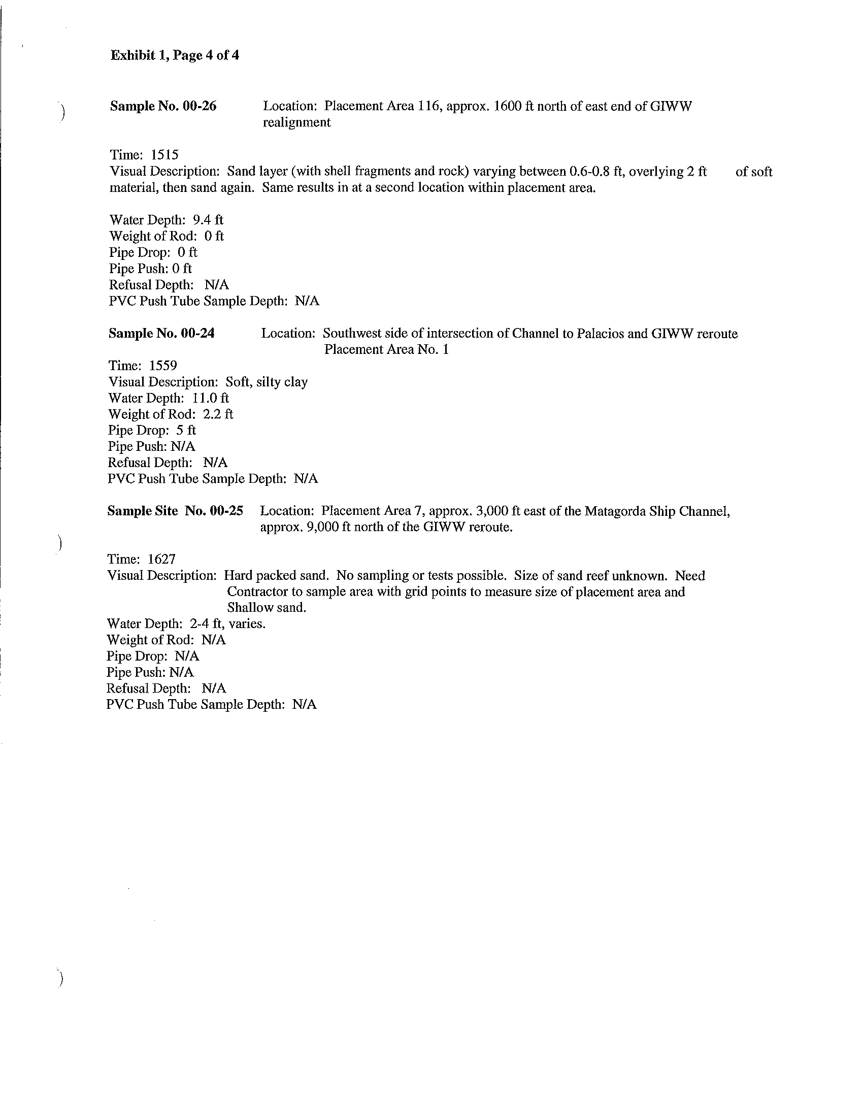
Exhibit 1, Page 4 of 4
Sample No.
00-26
Time: 1515
Location: Placement Area 116, approx.
1600
ft
north of east end of GIWW
realignment
Visual Description: Sand layer (with shell fragments and rock) varying between
0.6-0.8
ft,
overlying 2
ft
material, then sand again. Same results in at a second location within placement area.
Water Depth: 9.4
ft
Weight of Rod: 0 ft
Pipe Drop:
0
ft
Pipe Push: 0 ft
Refusal Depth:
NI
A
PVC Push Tube Sample Depth:
N/A
of soft
Sample No.
00-24
Location: Southwest side of intersection of Channel to Palacios and GJWW reroute
Placement Area
No.1
Time: 1559
Visual Description: Soft, silty clay
Water Depth:
11.0
ft
Weight of Rod: 2.2
ft
Pipe Drop: 5 ft
Pipe Push:
NI
A
Refusal Depth:
N/A
PVC Push Tube Sample Depth:
N/A
Sample Site No.00-25
Location: Placement Area 7, approx. 3,000 ft east of the Matagorda Ship Channel,
approx.
9,000
ft
north of the GrWW reroute.
Time: 1627
Visual Description: Hard packed sand. No sampling or tests possible. Size of sand reef unknown. Need
Contractor to sample area with grid points to measure size
of placement area and
Shallow sand.
Water Depth: 2-4
ft, varies.
Weight
of Rod:
N/A
Pipe Drop:
NI
A
Pipe Push:
NI
A
Refusal Depth:
N/A
PVC Push Tube Sample Depth:
N/A
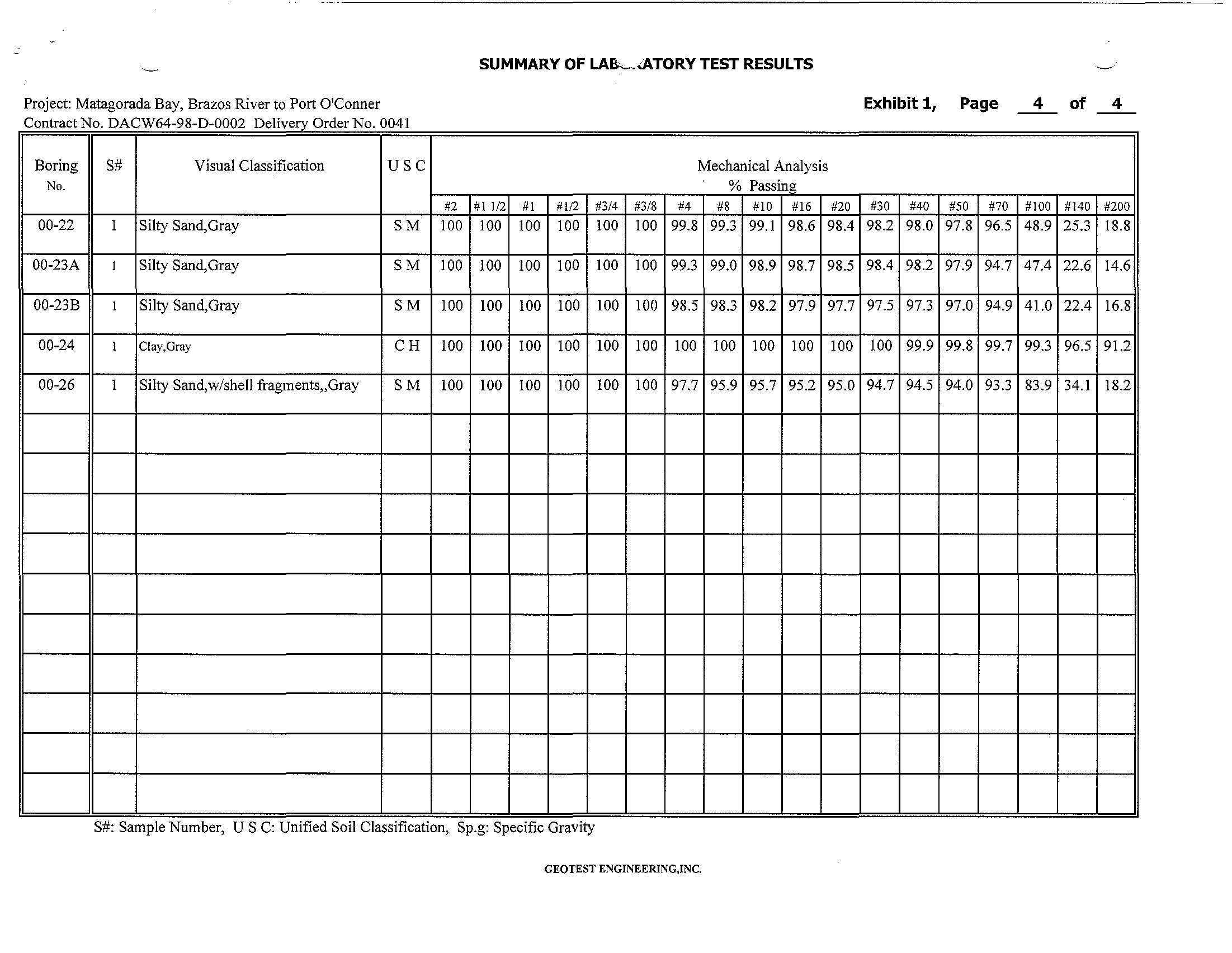
Project: GIWW Reroute - Matagorda Bay, Brazos River to Port O'Conner
SUMMARY OF LABORATORY TEST RESULTS
Contract No. DACW64-98-D-0002 Delivery Order No. 0041
SPT
Dry
Wet
Boring
Depth
PP Blows
Visual
USC
Me
Unit
Unit
No.
(It)
(lsf)
per
Classification
(%)
Wt
Wt
Foot
(pel)
(pel)
00-26
0-0.5
Silty Sand,Gray
SM
S #. Sample Number, P P . Pocket Penetrometer Reading, USC. Unified SOil Classlfcatlon, M c. MOisture Content
q u : Unconfined Compressive Strength, W
0
H : Weight of hammer, WOP: Weight of Pipe
Geotest
Engineering~
Inc.
Mechanical Analysis
LL
PL
% Passing
(%)
(%)
#4
#10
#40 #100
Tarvane
Shear
qu
Strength
#200
(tsf)
(tsf)
SUMMARY OF LA&-.<ATORY TEST RESULTS
Project: Matagorada Bay, Brazos River to Port O'Conner
Exhibit 1,
Page
4
of
4
C
on
tr
act
No. DACW64
-
98
-
D
-
0002 DerOd
Ivery r er
No. 0041
Boring
S#
Visual Classification
USC
Mechanical Analysis
No.
% Passing
#2
#1 112
#1
#112
#3/4
#3/8
#4
#8
#10
#16
#20
#30
#40
#50
#70
#100
#140
#200
00-22
1
Silty Sand,Gray
SM
100
100
100
100
100
100 99.8
99.3 99.1 98.6 98.4
98.2 98.0 97.8 96.5 48.9
25.3 18.8
00-23A
1
Silty Sand,Gray
SM
100
100
100
100
100
\00
99.3 99.0 98.9 98.7 98.5
98.4 98.2 97.9 94.7 47.4
22.6 14.6
00-23B
1
Silty Sand,Gray
SM
100
100
100
100
1