)
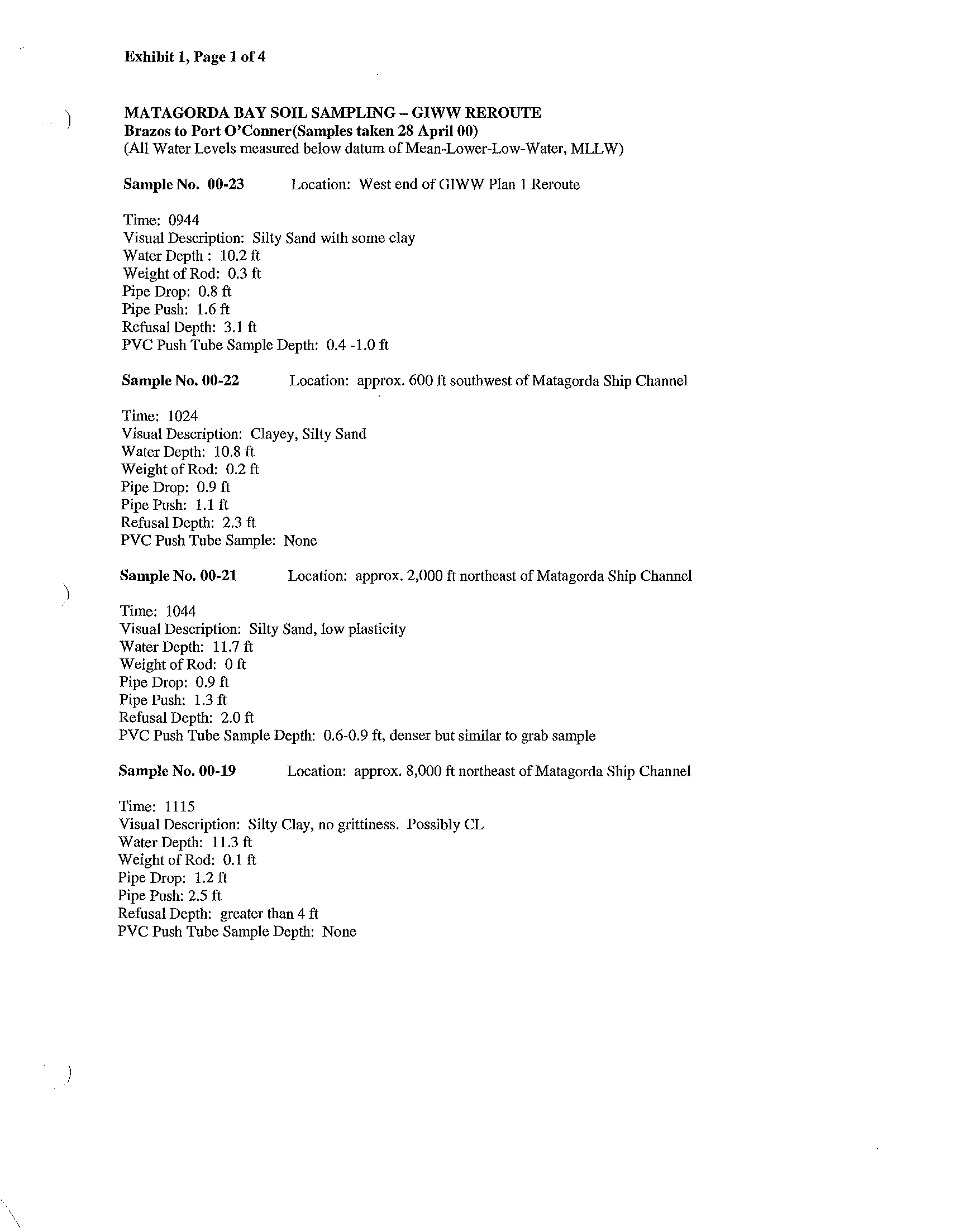
Exhibit 1, Page 1 of 4
MATAGORDA BAY
SOIL SAMPLING- GIWW REROUTE
Brazos to Port O'Conner(Samples taken 28 April 00)
(All Water Levels measured below datum of Mean-Lower-Low-Water, MLLW)
Sample No.
00-23
Location: West end of GIWW Plan 1 Reroute
Time:
0944
Visual
Description: Silty Sand with some clay
Water Depth: 10.2
ft
Weight of Rod: 0.3
ft
Pipe Drop: 0.8
ft
Pipe Push: 1.6
ft
Refusal Depth: 3.1
ft
PVC Push Tube Sample Depth: 0.4 -1.0
ft
Sample No. 00-22
Location: approx. 600
ft
southwest of Matagorda Ship Channel
Time: 1024
Visual Description: Clayey, Silty Sand
Water Depth: 10.8
ft
Weight of Rod: 0.2
ft
Pipe Drop: 0.9 ft
Pipe Push:
1.1 ft
Refusal Depth: 2.3 ft
PVC Push Tube Sample: None
Sample No. 00-21
Location: approx. 2,000
ft
northeast of Matagorda Ship Channel
Time: 1044
Visual Description: Silty Sand, low plasticity
Water Depth: 11.7
ft
Weight of Rod: 0
ft
Pipe Drop: 0.9
ft
Pipe Push: 1.3
ft
Refusal Depth: 2.0
ft
PVC Push Tube Sample Depth: 0.6-0.9
ft,
denser but similar to grab sample
Sample No.
00-19
Location: approx. 8,000
ft
northeast of Matagorda Ship Channel
Time: 1115
Visual Description: Silty Clay, no grittiness. Possibly CL
Water Depth: 11.3
ft
Weight of Rod: 0.1
ft
Pipe Drop: 1.2
ft
Pipe Push: 2.5
ft
Refusal Depth: greater than 4
ft
PVC Push Tube Sample Depth: None
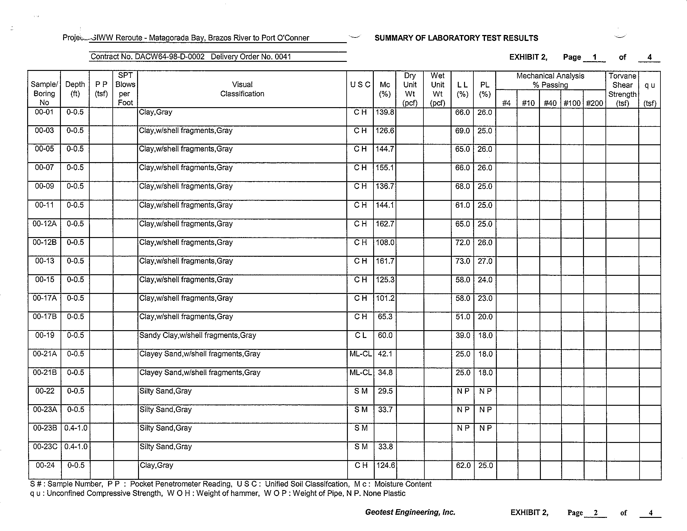
Projec...-3IWW Reroute - Matagorada Bay, Brazos River to Port O'Conner
SUMMARY OF LABORATORY
TEST
RESULTS
Contract No. DACW64-9S-D-0002 Delivery Order No. 0041
SPT
Dry
Wet
Samplel Depth
PP
Blows
Visual
USC
Me
Unit
Unit
Boring
(It)
(tsf)
per
Classification
(%)
Wt
Wt
No
Foot
(pel)
(pcf)
00-01
0-0.5
ClaY,Gray
CH
139.S
00-03
0-0.5
Clay,wlshell
fragments,Gray
CH
126.6
00-05
0-0.5
ClaY,wlshell
fragments,Gray
CH
144.7
00-07
0-0.5
Clay,wlshell fragments,Gray
CH
155.1
00-09
0-0.5
ClaY,wlshell fragments,Gray
CH
136.7
00-11
0-0.5
Clay,wlshell fragments,Gray
CH
144.1
00-12A
0-0.5
Clay,wlshell fragments,Gray
CH
162.7
00-12B
0-0.5
Clay,wlshell fragments,Gray
CH
10S.0
00-13
0-0.5
ClaY,wlshell
fragments,Gray
CH
161.7
00-15
0-0.5
ClaY,wlshell
fragments,Gray
CH
125.3
00-17A
0-0.5
Clay,wlshell fragments,Gray
CH
101.2
00-17B
0-0.5
ClaY,wlshell
fragments,Gray
CH
65.3
00-19
0-0.5
Sandy ClaY,wlshell
fragments,Gray
CL
60.0
00-21A
0-0.5
Clayey Sand,wlshell
fragments,Gray
ML-CL 42.1
00-21 B
0-0.5
Clayey Sand,wlshell fragments,Gray
ML-CL
34.S
00-22
0-0.5
Silty
Sand,Gray
SM
29.5
00-23A
0-0.5
Silty Sand,Gray
SM
33.7
00-23B 0.4-1.0
Silty Sand,Gray
SM
00-23C 0.4-1.0
Silty Sand,Gray
SM
33.S
00-24
0-0.5
ClaY,Gray
CH
124.6
S # . Sample Number, P P . Pocket Penetrometer Reading, USC. Unified
..
SOil Classlfcatlon, Me. MOisture Content
q u :
Unconfined Compressive Strength, WaH: Weight of hammer, WOP: Weight of Pipe, N P. None Plastic
Geotest
Engineering, Inc.
EXHIBIT 2,
Page
1
of
Mechanical Analysis
Torvane
LL
PL
%
Passing
Shear
(%)
(%)
Strength
#4
#10
#40 #100 #200
(tsf)
66.0 26.0
69.0 25.0
65.0 26.0
.
66.0 26.0
6S.0
25.0
61.0 25.0
65.0 25.0
72.0 26.0
73.0 27.0
5S.0
24.0
5S.0
23.0
51.0
20.0
39.0
1S.0
25.0
1S.0
25.0
1S.0
NP NP
NP NP
NP
NP
62.0 25.0
EXHIBIT 2,
Page_2_
of
4
q u
(tsf)
4
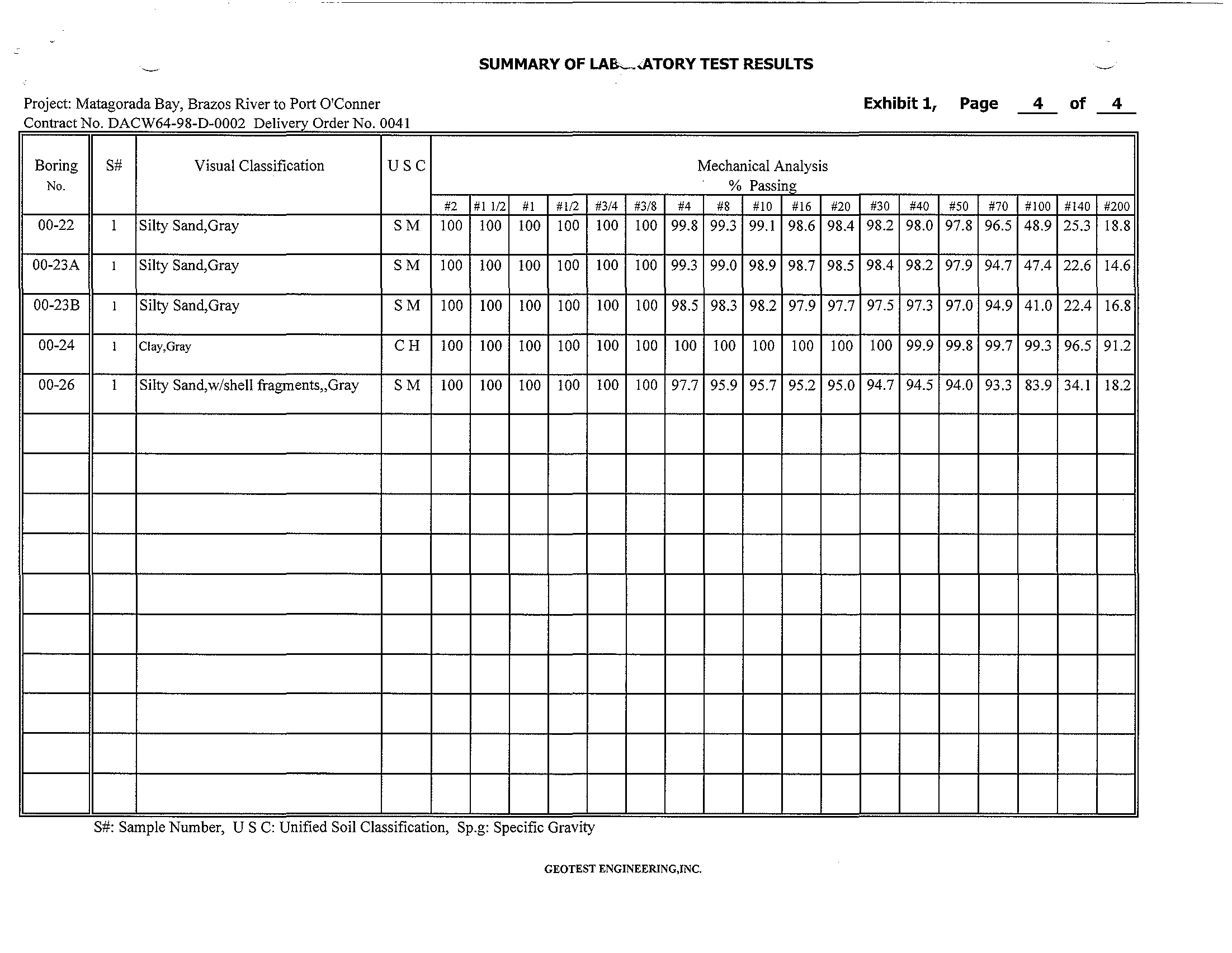
SUMMARY OF LA&-.<ATORY TEST RESULTS
Project: Matagorada Bay, Brazos River to Port O'Conner
Exhibit 1,
Page
4
of
4
C
on
tr
act
No. DACW64
-
98
-
D
-
0002 DerOd
Ivery r er
No. 0041
Boring
S#
Visual Classification
USC
Mechanical Analysis
No.
% Passing
#2
#1 112
#1
#112
#3/4
#3/8
#4
#8
#10
#16
#20
#30
#40
#50
#70
#100
#140
#200
00-22
1
Silty Sand,Gray
SM
100
100
100
100
100
100 99.8
99.3 99.1 98.6 98.4
98.2 98.0 97.8 96.5 48.9