ALEXANDER ISLAND
BORING SUMMARY SHEET
BORING ID:
13-P01
BORING TYPE:
Perimeter Levee
DEPTH:
60'
ELEVATION:
25.73'
X (US SURVEY FT):
3228153.92
Y (US SURVEY FT):
13827285.05
DEPTH TO WATER:
13.25'
Client: USACE-Galveston District
Boring:!
3
-Po}
(1281~
(
of.3
-'3-
,.;
""",,'
""'"".,,"",,.,,WM..WOW'"'........,,....._.w...,
''',"'' ""..."".
"",'_",",",,""m_''''
"'" ",,'00",,""
'w
..
"""'D"...
J~L'!f1.c;-I:::::
...
~;'
WJ..L:?:::.Ii.,'(,-;l).:::,/?,9..0..(,_'b
YD0
I
)'7'
8
)/
,
t5r~"ir'"..y rV/~~t.. Br~11
I
)1()/~+'
s:.It. Pr.
s.
A-.A-; 6ec«->lolI.-e/
,fJ.eI/
r;.j$.
:5
'4-.
Pt.
~ -lc>Il(~
L''jlt--r-
Q~y"-¢-1<...J.kft-.
!5fl
Vl
t'
S.A-.
A-~)
5'+:~F
S
.11-.
4: J
J...(Jwt'
~(""Y
-r
Y
....dCc,)t:s.t.... ora.':Y-
--5'. ..+.,4-
~,/..17hf
----
~
----
---
-----
.~.
Shear
Strength IDescription (SOIL TYPE, color, moisture, plasticity, consistency, density, inclusions. etc.)
(tsf)
/../0
j,7.S
J,7-5'
2,0
1.15
~5e.
;tIo1le.
,,-
/.0
Number IPocket
of
Tubes Pene.
(tsf)
7
q
7
8
.~
1'7
ll/
6-8
8-10
l~-l~
I~
--[Z,
s;-r
I
I
$11
I
$5
3-b-fo
\
0"
\
II
I
-
§!I
I
-
~Il
-
I 'Ll,-ll?I}'Z. I:TI: I
I
-
--
II
..
- ale"
l~:-l~
lq
s-r
\
),5
--
5 .. Jr,k
_
~
$i"I'ft.-- <:;"rr.Al'.D
,:
l-l-:h.-f:'
f-kcr.../"
/V,z,,-t'".
L.- 6 O<e.,
Sri-
r~
,:::-c.. 4/:,tu-!,
- St"\
\'6-2..0
1
1
3...
I
~..----"
~
de.yeYt
c)e-ca.}Ic,.......
1
~U
,fr"'J,$"<
.:J
5-tD-
'-0
~fh
A-.
I
Weather:
Dw..(C4-$+-1 (,rte'Z.:
""72.,°,e
(jI~
7,,1.13)'
OIle..rCAs1"
wi/lel
.4,;
50~
$e
....."
t"~
.R....;"'(sJ\Vrdcl.".. II.
'2.2../) @
"ro)fOVvC<""r;
g.,..<-<.~
-¥!f6?-
drzbJ3
: 1
I 0-2
::l
3M I
2-4
5
__
1
41
£111
I
4-6
DatelTime Drilling Begun:
II; 2/.
Uf3 1.5:(:1_
DatelTime Drillin"g Ended:
;/,21.2-0)]
~L/O
_.
.__
Driller~h.
NetA!
Logger:
&ct1~
M.-
Designated X
(Easting):~:z;l:rtt(l~14'7 l,...ll~ -'1S,()~o'l'10Co
_
"
Drill
Ri9:deb'l
g
5'1
a;l1.
tte.A1co
/h-f/{'aI""i"u/
PAr-fbrt'1.
Designated Y
(Northing):L~--r
z.,q,'"1lo';;i4i
Z (Elevation):
L~~~.p ":F~~(f4(~
Total depth:
fr>O.o
Q-.
Initial Water Encounter (Depth, date/time):
J
4,Ib
11.2-2...,)3
&.
0855'
Water Depth (15 min.):
J3,
'2..5' €
CJ9/0
I
S
I
Amount
Sample I
uscs
amp e
Material
~
Feet I Log
Interval Obtained
Blow
C
-R-)
(ft)
(in)
Counts
I
o
-----t---f----+---+---i---+----f---+-----------------------~-........_l
I
S'
LL
\/
II
''-'
,,.-:-
'-rtt. tl
CC<t.s-fbA. ...
1
'/Try
S;1)"!.D
I reltM,)...
!)fa'j'l.J'iJ;d;
L60~!L1
sA I..r. r-e... WI
~/""II
-rr>:Lp
10 -J
c.t\
US Army Corps of Engineers. Southwestern Division
Galveston District
2000 Fort Point Road/P.O. Box 1229
Galveston, TX 77553-1229
Alexander Island
Houston Ship Channel
Baytown, TX
I@RI
Quaternary Resource Invc'stigatiol1s,
I..L.e.
Government
&
Industi)' ill HarmollY with the Environmellt
13588 Flol'itht Boulevard, Baton Rouge, Louisi:lll:1 70819
/.3 -
r)O!
ui;
~~
-i3-
,,~
_",,, ._ , ,.,
, ,••••""••,,
__
,~JI/,
.,rad:..._
1
L?!I.t:.:P-()(J/-.:I>Yb(P
Client: USACE-Galveston District
Boring: /3
-PM
-------"
Page 2
cl> oF 3
w __w,,__
------
D;z5
Sample
Amount
Sample
P
k
F
t
USCS
Material
Type
Number
oc et
Shear
(4)
- Log
Int~0al
Obt~ined
Blow
of Tubes
~:pe.
Strength Description (SOIL TYPE, color, moisture, plasticity, consistency, density. inclusions, etc.)
II
/
20 .
(In)
Counts
()
(tsf)
'~
.-
'U;-1.'L
I
~
~,
J
DeS"
_
OrylZA-fC tV.-IW
lPa.*-tl<-~T'}-{
d(S.t- H-i'-7k
~e<->+(c/+'QI ~f4'n--
I
_.
C-It/Dlf
-
I
~t,
1',
1:Z-'l¥
q
s-r
]
..;;;;.--
~fJ"UJ
(1.2<
-d
1)..7-5
51'A;U
II <
~<{·lJ
e.~:.35
30
I
..
'I
}")1'
Qunkrnarv Resource
rnv~stjga1ions,
L.L.c.
1,>.
~l
.:\'
Governmel;t
&
.lndlJstry'
ill
Har;lOllY with the Environmellt
13588 Florida 13011levarcl, Baton Rouge, Louisi:1ll::t 70819
6.2.~
D,'5
. I
5,T
'31
-j
1
1.$2.-1
~I
1Y
35
~
Bejo H
]4--3~
)
L
- Jr
3~-3s
110
~
I
0,5'
-:,'
5.1f.A-.
II
I
(
3S
40
-
SM
3B-lfo
J:)
~
1.{6
cJtl.~YI3//.fy
SfI-I.l-Q-.
(~Gto/ v1~t
(LDo$C?-0/r'ts
Y"",e",
bfel~
...JS,
Weather:
OVl!.~rt-l ~1'.49bf'
C!1,z,3.1U.;
Mre..vt
1M(£.
r
""",,1i6°~
(j1,z.t{.I3)
us Army Co:ps. of Engineers, Southwestern Division
Alexander Island
Galveston Dlstnct
.
2000
Fort Point Road/P,O, Box 1229
Houston Ship Channel
Galveston, TX 77553-1229
Baytown, TX
Client: USACE-Galveston District
-13-
M'.,," ....
" ... ""......
,,*,,__"' "',,_ ". '_'"",'"'''''",,''''' ,"
,
'""".""',,'",,.,,'..'••••••,."
M",,""
_
&ztJ.-f!.::Ect- M:.".I4L,ql2-Ji.:I.
,Q.:;;Mf
:D!CXo
Boring:
/3
-Po
I
Page 3
J43
_._--_.
-
-
_._-----------
Total depth:
62(),D
Sample
Amount
USCS
Material
Feet
Log
Interval
Obtained
(.ft-)
(tt)
(in)
40 _._,--
-
LjD--L/Z.
}B
J i
42-l.(y
18
45 _..._.,
'iLf"Y&
lB
-~
51"\
14kLfSI
/2
:t
Li8-50
18
50-
5"D~5'1..
JB
-
~-z.->y
)g
.,-
Sample
Type
Blow
Counts
.$-.
3-3 'l.
2J-
3 -'2.:'1
&--
WDC(.J,-J
.§r-
IWDI\-t/-3
.2.£.-.
Ilu~-9-1..
,,&£-
WMI..-?r1
2'£-
1-7..-3
Number IPocket
Shear
of Tubes Pene.
Strength
(tst)
(tst)
I
/'
,.-
I
/"
I
r
\
,..".
I
..--
--
\
/'
I
/'
\
,-/
I
..--
\
r
"....--
1
"....--
---
DatelTime Drilling Ended:
I/. ZL/.I
3
~ /.~d
Description (SOIL TYPE, color, moisture, plasticity, consistency, density, inclusions, etc.)
S,
f\ '
Pr, ('
\f<Z.I'¥
L
o
0,5.e..
s.
Pr. A (
V(l,'o Lose
s..fr.
Pr 1
LooSe.
S,
Pr.
It
I
doM
foN
.....
Ca-rLoAG.«Gc.>.,S -h-a.j..s,
I Ltb{fl-
'3 -
fr-Pr I
Leos'<.
.5,
fr.A)
OCCGtS'r'oJ
sl"..cl
-0--~j;
I
~J~L
s; ,
PI. A- (
C!...b/ot-~,,-
51lf'l)
d~'O O-~
La..A1..5.
I\/"'
Lso... e...
¥-
S'5'~
55 --i
,$'L.I-r~)
g
J
/'
,/
c1,,,Iu'"
,'If.
e.l
", ..I
,s
TL
'"t
""",>,
$t-
~1r.-5B
/5
1
/'
/
Slt-.Pr. 1
Jeff.( S,'I+y
ILOO.s~
60
-
}
$ll-(,D
I
----
$..Pr.
Pc.
AL~t
,"[f
y
~
/"",",$
(~~ W!.1""'~'-'
-EC.,r./IL",;e.
UGslArm
y
CDO~PtS,
of Engineers, Southwestern Division
Alexander Island
f'~
.
Quaternary Rest)urce Invc:-stigations,
L.L.c.
a veston IS net
H
t
Sh'
CI
I
'El~RI
G'
&J
I
'f.eT
~
h hE'
2000 Fort Point Road/P.O. Box 1229
ous on
/P
Janne
~..
~V~rnl1lel:t.
nc. ustr)'
11l,
larmollY
wit
t e...
nVlr~nl1lellt
Galveston, TX
77553-1229
Baytown, TX
1.)588
Flol'ld~{
Boulevard. Baton Rouge,
L.Ol!lSl~trla
;0019
16
14
16
24
34
29
28
37
96
86
21
92
45
42
53
120
120
10
12
20
22
22
20
26
22
21
16
51
59
44
27
68
61
107
107
99
105
71
66
59
67
0.2
0.15
0.1
1.10
-/1.0
2.0
1.25
1.25
1.75
1.0
1.5
0.5
0.25
0
0
0
0.5
0.5
6
8
14
14
7
7
9
12
19
13
16
9
16
15
17
17
14
ST
ST
SS
ST
ST
ST
ST
ST
ST
SS
ST
ST
ST
SS
SS
ST
ST
3-6-6
(12)
5-6-6
(12)
5-4-6
(10)
2-2-2
(4)
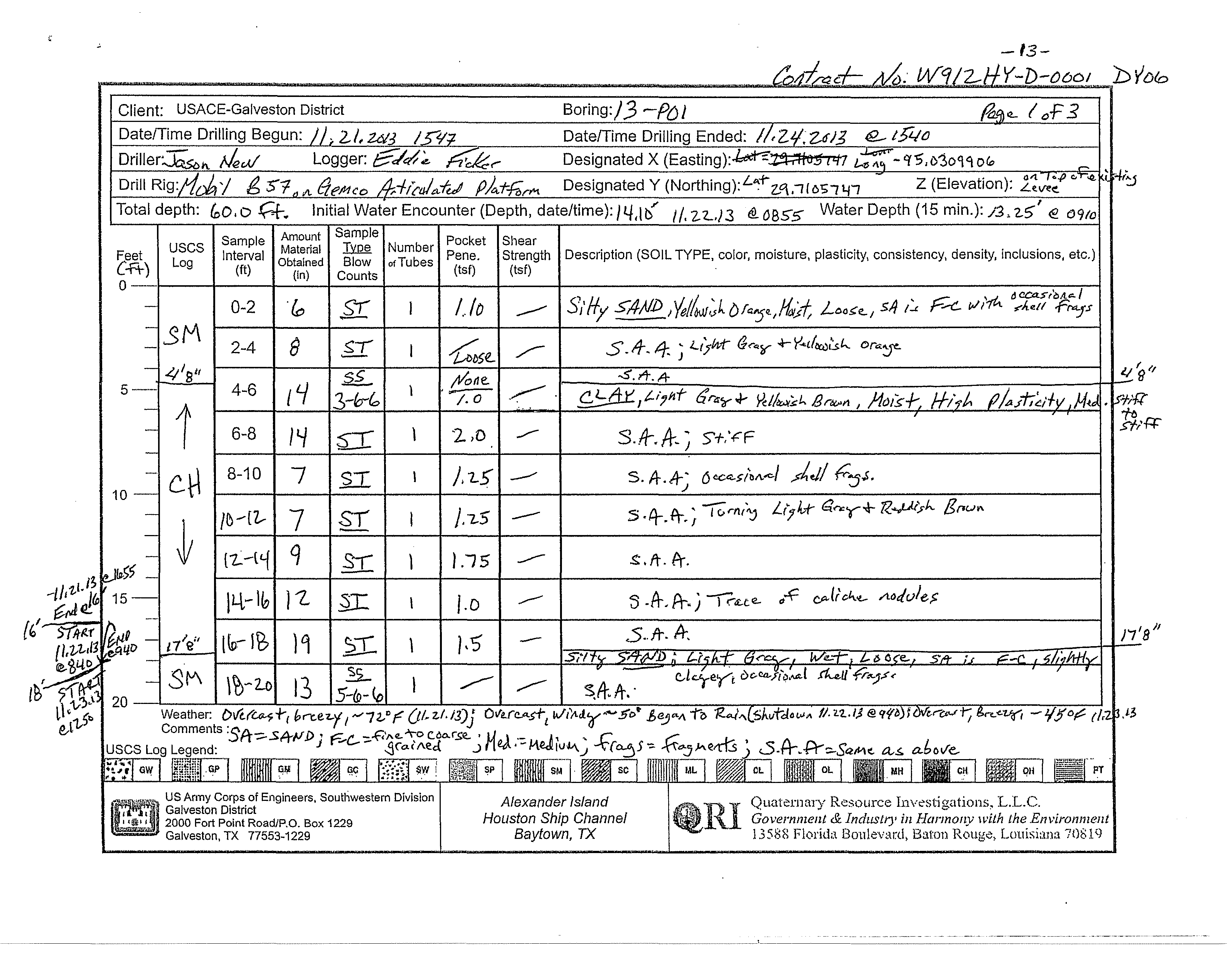
Silty SAND; fine to coarse grained,
yellowish orange, moist, loose, with
occasional shell fragments
light gray and yellowish orange
CLAY; light gray and yellowish brown,
moist, high plasticity, medium stiff to stiff
stiff
with occasional shell fragments
light gray and reddish brown
CLAY; light gray and yellowish brown,
moist, high plasticity, medium stiff to stiff,
with a trace of caliche nodules
Silty SAND; fine to coarse grained, light
gray, wet, loose, slightly clayey, with
occasional shell fragments
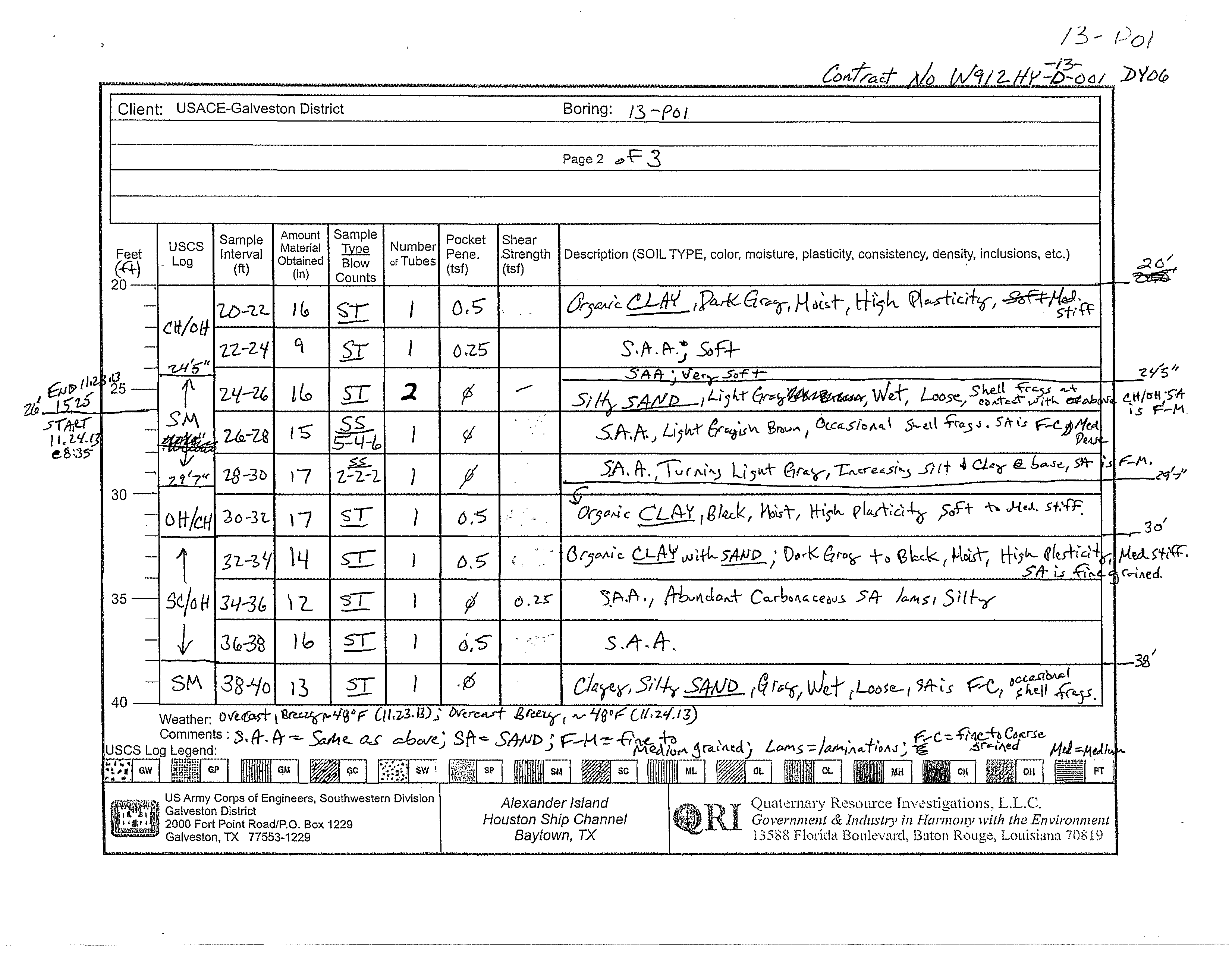
CLAY; dark gray, moist, high plasticity,
medium stiff
soft
very soft
with fine to medium grained sand, light gray,
wet, loose, shell fragments layer at 24.5'
with fine to coarse grained sand, light
grayish brown, occasional shell fragments,
medium dense
with fine to medium grained sand, light gray,
silt and clay increasing with depth
black, moist, high plasticity, soft to medium
stiff, no sand
dark gray to black, moist, high plasticity and
medium stiff, with fine grained sand
SM
CL
CH
SM
CH
CL
1.11
0.68
0.77
0.81
0.53
1.00
11
5
6
2
2
2
0
0
11
13
0
17
DRILLING CONTRACTOR
QRI
LOGGED BY
Eddie Ficker
GROUND ELEVATION
25.7269 ft
NORTHING
13827285 ft
WEATHER
cloudy, 70s to 40s, breezy to windy, some rain
GROUND WATER LEVEL
HOLE SIZE
8.25 inches
EASTING
3228154 ft
DRILLING METHOD
Hollow Stem Auger
DRILLING RIG MAKE/MODEL
Mobile B57 on Gemco Articulated Platform
TOTAL DEPTH
60 ft
DATE STARTED
11/21/2013 3:47:00 PM
COMPLETED
11/24/2013 3:40:00 PM
AT TIME OF DRILLING
14.10 ft / Elev 11.63 ft
24 HOURS AFTER DRILLING
13.25 ft / Elev 12.48 ft
(Continued Next Page)
PLASTIC
LIMIT
PLASTICITY
INDEX
MINUS #200 SIEVE
CONTENT (%)
LIQUID
LIMIT
ATTERBERG
LIMITS
MOISTURE
CONTENT (%)
DRY UNIT WT.
(pcf)
FIELD TORVANE
(tsf)
POCKET PEN.
(tsf)
RECOVERY
(in)
SAMPLE TYPE
DEPTH
(ft)
0
5
10
15
20
25
30
35
SPT BLOW
COUNTS
(N VALUE)
GRAPHIC
LOG
MATERIAL DESCRIPTION
USCS SYMBOL
COMPRESSIVE
STRENGTH (tsf)
FAILURE
STRAIN (%)
CONFINING
PRESSURE (psi)
PAGE 1 OF 2
BORING NUMBER 13-P01
CLIENT
USACE-Galveston District
PROJECT NUMBER
W912HY-13-D-0001-DY06
PROJECT NAME
Alexander Island
PROJECT LOCATION
Alexander Island, Baytown, TX
COPY OF PEGGY LAKE GEOTECH BH - PEGGY LAKE TEMPLATE.GDT - 4/4/14 15:03 - F:\QRI DATA\TECHNICAL\JOBS (CURRENT)\ACE - GALVESTON\2012-12-20 GEOTECHNICAL CONTRACT\TASK ORDER DY06 2013-09-10 ALEXANDER ISLAND\DELIVERABLES\ALEXANDE
Quaternary Resource Investigations, LLC
13588 Florida Boulevard
Baton Rouge, LA 70820
Telephone: 225-292-1400
Fax: 225-292-1404
15 24 89
20
15
64
33 39
35
20
22
22
22
19
21
21
27
32
31
30
83
84
0.25
0.1
0
0.5
0
12
16
13
18
18
18
13
18
18
18
18
15
17
ST
ST
ST
SS
SS
SS
SS
SS
SS
SS
SS
SS
SS
3-3-2
(5)
3-2-1
(3)
0-3-3
(6)
0-4-3
(7)
0-3-2
(5)
0-3-2
(5)
1-2-3
(5)
3-3-4
(7)
2-3-4
(7)
3-3-3
(6)
Silty CLAY, dark gray to black, moist, high
plasticity, medium stiff, with abundant
carbonaceous sand laminations
(continued)
Silty SAND; fine to coarse grained, gray,
wet, loose, with occasional shell fragments
very loose
loose
carbonaceous fragments common
occasional shell fragments
very loose, silty clay laminations common
CLAY; gray, moist, loose, with common silty
clay laminations and some fine to coarse
grained sand
very silty
abundant silty clay laminations,
carbonaceous fragments common
Bottom of borehole at 60.0 feet.
CL
SM
CH
0.93 5
0
PLASTIC
LIMIT
PLASTICITY
INDEX
MINUS #200 SIEVE
CONTENT (%)
LIQUID
LIMIT
ATTERBERG
LIMITS
MOISTURE
CONTENT (%)
DRY UNIT WT.
(pcf)
FIELD TORVANE
(tsf)
POCKET PEN.
(tsf)
RECOVERY
(in)
SAMPLE TYPE
DEPTH
(ft)
35
40
45
50
55
60
SPT BLOW
COUNTS
(N VALUE)
GRAPHIC
LOG
MATERIAL DESCRIPTION
USCS SYMBOL
COMPRESSIVE
STRENGTH (tsf)
FAILURE
STRAIN (%)
CONFINING
PRESSURE (psi)
PAGE 2 OF 2
BORING NUMBER 13-P01
CLIENT
USACE-Galveston District
PROJECT NUMBER
W912HY-13-D-0001-DY06
PROJECT NAME
Alexander Island
PROJECT LOCATION
Alexander Island, Baytown, TX
COPY OF PEGGY LAKE GEOTECH BH - PEGGY LAKE TEMPLATE.GDT - 4/4/14 15:03 - F:\QRI DATA\TECHNICAL\JOBS (CURRENT)\ACE - GALVESTON\2012-12-20 GEOTECHNICAL CONTRACT\TASK ORDER DY06 2013-09-10 ALEXANDER ISLAND\DELIVERABLES\ALEXANDE
Quaternary Resource Investigations, LLC
13588 Florida Boulevard
Baton Rouge, LA 70820
Telephone: 225-292-1400
Fax: 225-292-1404
3/8 4 10 40 100 200 gravel sand silt clay
sieve
200
C Wc γd
C Wcγd
C φ Wc
C φ c̕φ̕Wcγd
ft
tsf tsf bl/ft % % % % % % % % % % % % % %
% pcf
ksf
% pcf
ksf
% pcf
ksf
º
%
ksf
º
ksf
º
%
pcf
USCS
Symbol
SUMMARY TABLE OF LABORATORY TEST DATA
Unconfined Compression
UU Triaxial Test
CU Triaxial Test
Symbol
Symbol
Symbol
γd
Direct Shear
Symbol
Strenght Tests
Wc
Atterberg Limits
PP
% by weight passing sieve
Client: QRI
Terracon Project # : 92135456
Grain Size Analysis
SPTn
Project Name: Alexander Island
Boring
Depth
LL
PL
PI
Field Tests
TV
0-2
-
100
100
98
65
5
0
95
5
SP-SC*
13
2-3.5
3.5-5
-
10
100
100
99
69
25
0
75
22
3
25
SM*
23
5-8.5
8.5-10
-
3
26
10-13.5
13.5-15
-
2
25
0-2
-
99
99
98
84
30
1
69
30
SC*
18
2-3.5
3.5-5
-
26
100
100
82
4
0
96
4
SP*
20
5-8.5
8.5-10
-
6
100
100
99
82