ALEXANDER ISLAND
BORING SUMMARY SHEET
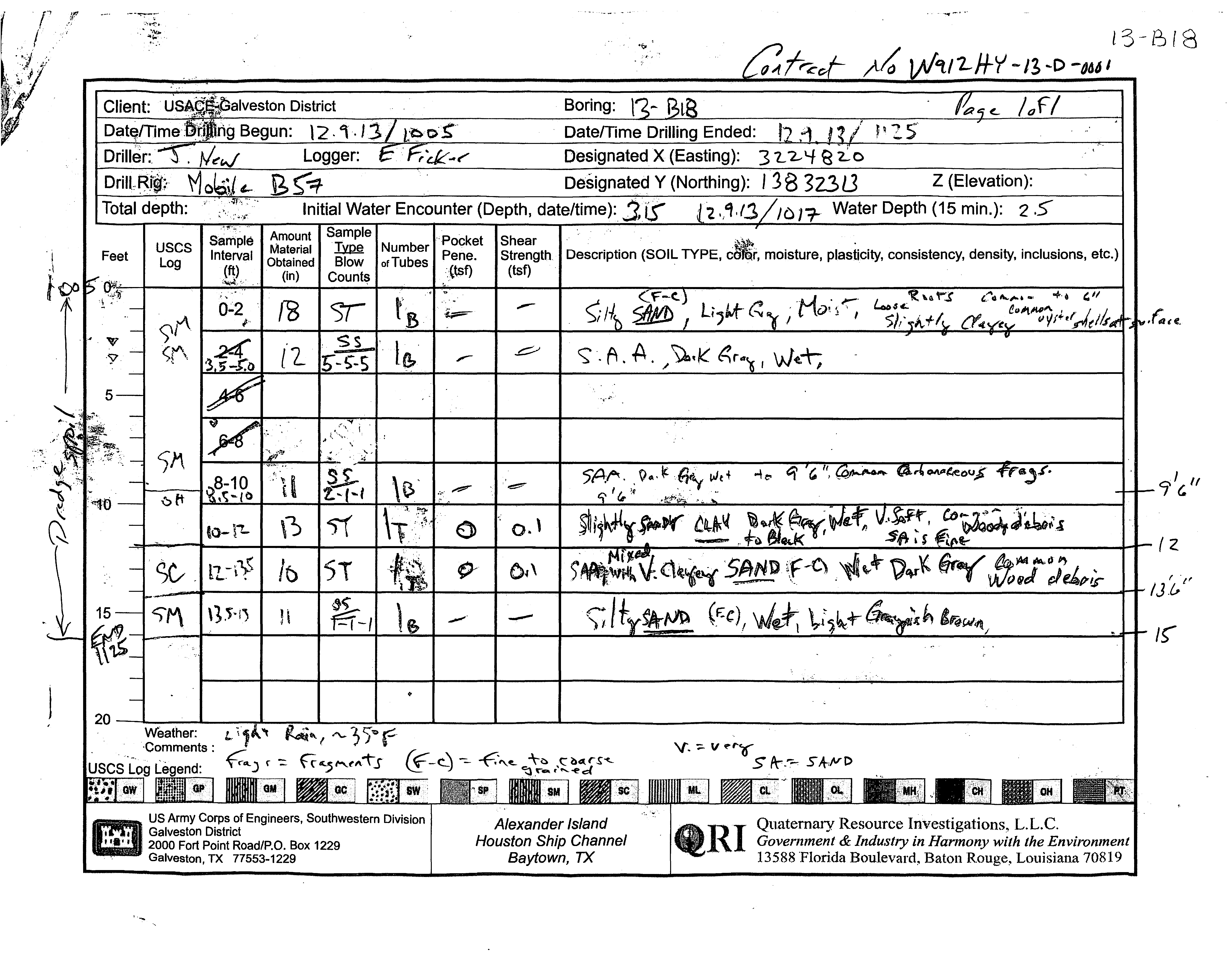
BORING ID:
13-B18
BORING TYPE:
Borrow Source
DEPTH:
15'
ELEVATION:
29.49'
X (US SURVEY FT):
3224819.95
Y (US SURVEY FT):
13832313.05
DEPTH TO WATER:
2.5'
-:0;.
5
'1U
15
~
-" ..
~
.
. '
';\9.-
.~
..
:.
uses
Log
Boring:
Datemme
,q : S
Desi
X (Easting):
3
L 2-,-/
e
13~1~{8
12.H-~
- n -D
-0661
Designated Y
(Northing):
138
3Z3l3
Z (Elevation):
Initial Water Encounter (Depth, date/time):
. '2.,".(,3
Water Depth (15 min.): 2.5'
S . Ie
Amount
Sample
Pocket
amp
Material
Thllil.
Number
Interval
Obtained
Blow
of Tubes
Pene.
(in) Counts{tsf)
~rr:~~th
Description (SOIL TYPE,
ctl;r,
moisture, plasticity, consistency, density, inclusions, etc.)
(tsf)
i.;=-
--
~
,
Mo,,'j~
9'~
r-__
~
____
~~
__
+--=~~
__-+____-+____
~
____
~
______
-L_'________
~~~~~~~~~~~~~~~'r.,~
<;r"
)1'\
)p,;~
..
Q...
~e-
9'(.11
.-?"
~
'=>tt
(0-
i"'t.
~
O. \
(2
~,
l1.~i~
51
~~
o~,
/J.'&"
~S"
')'/'1\
\l.~'i'~
l\
fEr-I
-'
-
"
~ ~f4w,ft
I~
20--~~~
__
~~~~~~~~
__
~
__
~
____
~
________________________________________________
~
I
~
))1>(-
US Army Corps of Engineers, Southwestern Division
Galveston District
.
2000 Fort Point Road/P.O. Box 1229
Galveston, TX 77553-1229
Alexander Island
Houston Ship Channel
Baytown, TX
v. -;.
V""O
S Pr.';., S
/tJVD
Quaternary Resource Investigations,
L.L.c.
Government
&
Industry in Harmony with the Environment
13588 Florida Boulevard, Baton Rouge, Louisiana 70819
DY06
29
29
80
69
16
6
92
93
109
98
13
19
50
70
83
20
0.1
0.1
-
-
-
0
0
-
18
0
12
0
11
13
10
11
ST
NR
SS
NR
SS
ST
ST
SS
5-5-5
(10)
2-1-1
(2)
1-1-1
(2)
Silty SAND; fine to coarse grained, light
gray, moist, loose, slightly clayey, with roots
(common to 6") and common oyster shells
at surface
dark gray, wet
SAND with SILT; fine to coarse grained,
light gray, moist, loose, slightly clayey, with
roots (common to 6") and common oyster
shells at surface
common carbonaceous fragments
CLAY; dark gray to black, wet, very soft,
with fine grained sand and common woody
debris
with fine to coarse grained sand, wet, dark
gray, with common wood debris
Silty SAND; fine to coarse grained, wet, light
grayish brown
Bottom of borehole at 15.0 feet.
SM
SP-
SM
CH
SM
DRILLING CONTRACTOR
QRI
LOGGED BY
Eddie Ficker
GROUND ELEVATION
29.4891 ft
NORTHING
13832313 ft
WEATHER
light rain, mid 30s
GROUND WATER LEVEL
HOLE SIZE
8.25 inches
EASTING
3224820 ft
DRILLING METHOD
Hollow Stem Auger
DRILLING RIG MAKE/MODEL
Mobile B57 on Gemco Articulated Platform
TOTAL DEPTH
15 ft
DATE STARTED
12/9/2013 10:05:00 AM
COMPLETED
12/9/2013 11:25:00 AM
AT TIME OF DRILLING
3.15 ft / Elev 26.34 ft
24 HOURS AFTER DRILLING
2.50 ft / Elev 26.99 ft
PLASTIC
LIMIT
PLASTICITY
INDEX
MINUS #200 SIEVE
CONTENT (%)
LIQUID
LIMIT
ATTERBERG
LIMITS
MOISTURE
CONTENT (%)
DRY UNIT WT.
(pcf)
FIELD TORVANE
(tsf)
POCKET PEN.
(tsf)
RECOVERY
(in)
SAMPLE TYPE
DEPTH
(ft)
0
5
10
15
SPT BLOW
COUNTS
(N VALUE)
GRAPHIC
LOG
MATERIAL DESCRIPTION
USCS SYMBOL
COMPRESSIVE
STRENGTH (tsf)
FAILURE
STRAIN (%)
CONFINING
PRESSURE (psi)
PAGE 1 OF 1
BORING NUMBER 13-B18
CLIENT
USACE-Galveston District
PROJECT NUMBER
W912HY-13-D-0001-DY06
PROJECT NAME
Alexander Island
PROJECT LOCATION
Alexander Island, Baytown, TX
COPY OF PEGGY LAKE GEOTECH BH - PEGGY LAKE TEMPLATE.GDT - 4/4/14 15:03 - F:\QRI DATA\TECHNICAL\JOBS (CURRENT)\ACE - GALVESTON\2012-12-20 GEOTECHNICAL CONTRACT\TASK ORDER DY06 2013-09-10 ALEXANDER ISLAND\DELIVERABLES\ALEXANDE
Quaternary Resource Investigations, LLC
13588 Florida Boulevard
Baton Rouge, LA 70820
Telephone: 225-292-1400
Fax: 225-292-1404
3/8 4 10 40 100 200 gravel sand silt clay
sieve
200
C Wc γd
C Wcγd
C φ Wc
C φ c̕φ̕Wcγd
ft
tsf tsf bl/ft % % % % % % % % % % % % % %
% pcf
ksf
% pcf
ksf
% pcf
ksf
º
%
ksf
º
ksf
º
%
pcf
USCS
Symbol
SUMMARY TABLE OF LABORATORY TEST DATA
Unconfined Compression
UU Triaxial Test
CU Triaxial Test
Symbol
Symbol
Symbol
γd
Direct Shear
Symbol
Strenght Tests
Wc
Atterberg Limits
PP
% by weight passing sieve
Client: QRI
Terracon Project # : 92135456
Grain Size Analysis
SPTn
Project Name: Alexander Island
Boring
Depth
LL
PL
PI
Field Tests
TV
0-2
-
100
100
99
68
6
0
94
6
SP-SC*
14
2-3.5
3.5-5
-
17
94
94
93
74
18
8
6
86
8
SP-SM*
19
0.14
35
19
SP**
Hydrometer could not be properly performed due to low fine content. Direct shear
classified as unsuitable during suitability testing. Suitable during sample preparation.
5-8.5
8.5-10
1.25
0.55
3
21
10-12
1.25
0.55
37
13
24
100
100
99
96
69
0
31
69
CL
22
12-13.5
-
26
13.5-15
-
7
19
0-2
-
100
99
99
80
16
1
83
16
SM*
13
2-3.5
3.5-5
-
10
100
99
84
16
6
0
94
3
3
6
SP-SM*
19
5-8.5
8.5-10
-
2
50
10-12
0
0.1
109
29
80
100
99
92
0
8
92
CH
70
12-13.5
0
0.1
98
29
69
100
100
100
98
93
0
7
93
CH
83
13.5-15
-
2
20
0-2
0
0.15
43
16
27
97
95
93
73
43
5
52
43
SC
26
2-4
0
0.15
30
4-5
-
100
99
97
80
30
1
69
30
SC*
23
5-8.5
8.5-10
-
47
19
10-13.5
13.5-15
-
3
43
0-2
-
100
99
99
79
47
1
52
47
SC*
36
2-3.5
3.5-5
-
5
100
100
100
98
47
0
53
47
SC*
25
5-8.5
8.5-10
-
11
23
10-13.5
13.5-15
-
4
26
0-2
-
30
2-3.5
3.5-5
-
2
100
99
99
95
28
1
71
28
SC*
27
5-8.5
8.5-10
-
2
100
100
100
94
10
0
90
10
SP-SC*
22
10-13.5
13.5-15
-
2
32
0-2
1.25
100
99
97
94
0
6
94
CH*
37
2-4
1.5
62
22
40
CH*
26
4-6
0.75
20
6-8
0.5
52
21
31
CH*
25
8-10
-
97
95
94
82
34