ALEXANDER ISLAND
BORING SUMMARY SHEET
BORING ID:
13-P03
BORING TYPE:
Perimeter Levee
DEPTH:
60'
ELEVATION:
23.82'
X (US SURVEY FT):
3224485.02
Y (US SURVEY FT):
13828683.79
DEPTH TO WATER:
10.7'
I
1
~
I.
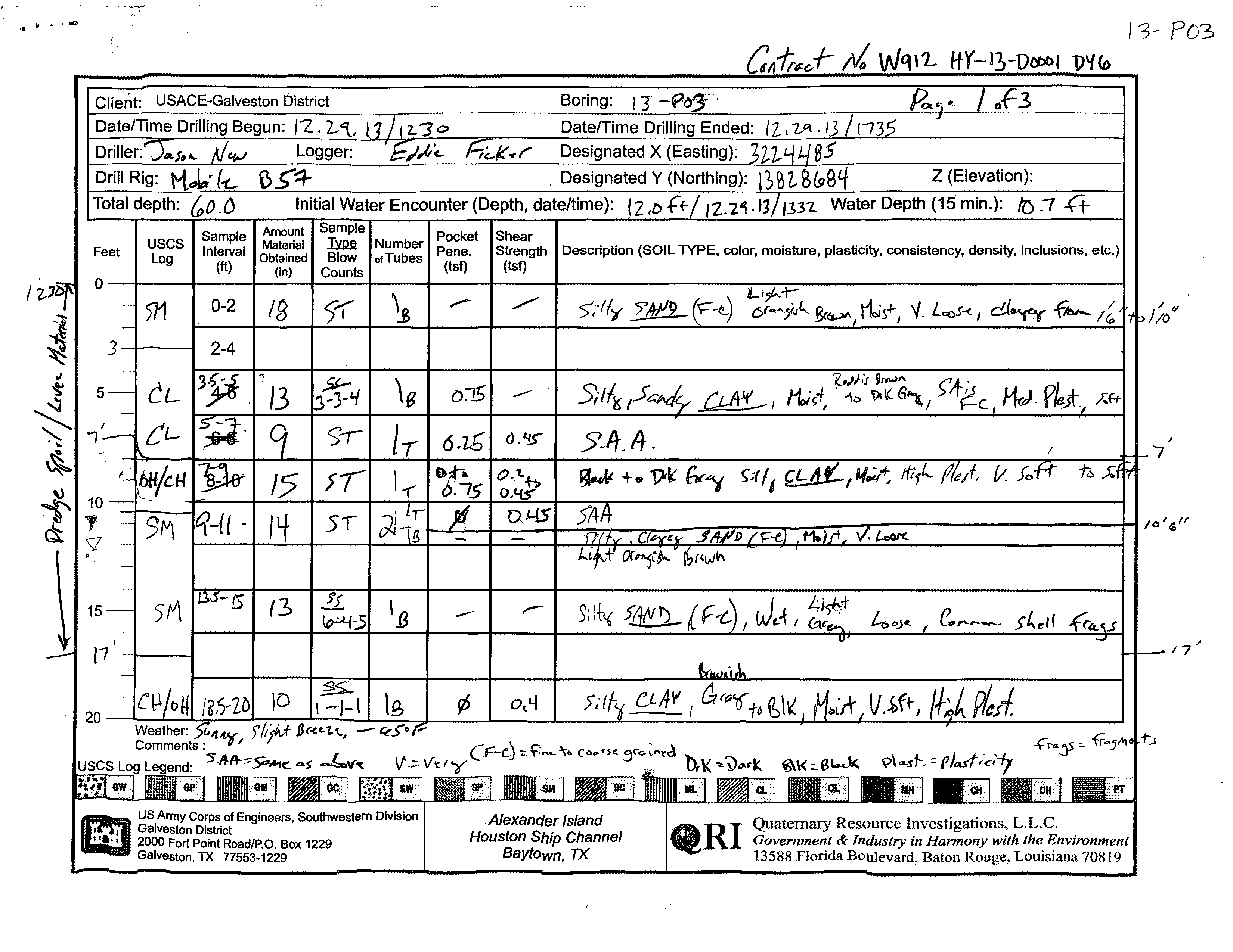
Client: USACE-Galveston District
Date/Time Drilling Begun: /'2.,2-1.,
Dril
Logge~
Drill Rig:
e~-::r
Initial Water Encounter (Depth, date/time):
Sample
Amount
uses
Material
Feet
Log
Interval
Obtained
(ft)
(in)
0
571
0-2
IB
3
2-4
r
11
fr
51
Number Pocket
of Tubes Pene.
(tst)
\e
D~
J
Shear
Strength Description (SOIL TYPE, color, moisture, plasticity, consistency, density, inclusions, etc.)
(tst)
..--
5>11'6
OA'L-I
l1oh:f
-tD
\A \( S",
I
->,f
~-L
J{J.
p~
I
d.'!.)
S.Jt.
t4 .
t;;(1,
,I./~
tftr'"
IlPlllIIiIIIII:D us Army Corps of Engineers, Southwestern Division
Galveston District
.AlexanC/er Island
Houston
Ship Channel
Baytown,
TX
Quaternary Resource Investigations,
L.L.c.
Government
&
Industry in Hannony with the Environment
13588 Florida Boulevard, Baton
Rouge,
Louisian.a
70819
_-. 2000 Fort Point Road/P.O. Box 1229
-
Galveston, TX 77553-1229
1'3- P03
I f/
//0
I
7
IC/
d,
rr
23.8203'
..
i
'.
"
C"if.I?<--r
1110
Wet/'L
HY-13-D(}OD1
DYo~
I
I~
7\
I I
I
USACE-Galveston District
Boring:
Page 2
Sample
Amoun
.:>i:llllf)ltl
I I
Pocket
I
Shear
I USCS
Material
~
Number Pene.
Strength
Feet
Interval
Obt~ined
Blow
of Tubes (tsf)
(tsf)
Log
(tt)
(In)
Counts
20
Description (SOIL TYPE, color, moisture, plasticity, consistency, density, inclusions, etc.)
c~lo!+-
:LO:a
1&
~I
Ctt
/]A
-",1
13
151
/
l
~
I
0.1,>
'I .....H1
~
a
l,:l It'
I I
,J-.f &/,
•
,
.. 1/,_/1
Jlll'A.,e\
/I"'-'j!
'111 __
'-,J
/l.
I.r.i
I
AI
I~_-I-"""
__
I
II
..1 -.'
.
.-
v
.1/"
/~
,.
~L.~1ot'-"1
-
......-
-11'
.. -
--r
,-
.J'"
~
- -
~zy
,'l1?s
Ie)
SS"
\ fl
_...
0..
6,3.)
)/'Oy
~
I
~,,;{L." (ir.~
'h
~I
K., !VIQ;r-/
Hr',t..
(l14.!~,
S'of.f-
"
I
()
"2--2--3
1>
-
-
v. >itf....
~D
U:--t-...\
: ..f.uof-
frJr"DUrn
-
w~.,.
Ware. I
<;"//c.t..rt.., L
r..-.~...
"l..~
,
'"
"
,
rJ
\J"
"U-'
...
J
I
I
<if
I'
: t
_
I
;>" ,
I
~
_, "
I
~
.n
LI
•
-1.
~'-'--6
:z;; /
/1/
_J..
1
2-
30
')1.-
'3'1
___
I
______
w~"t 'oA-~;I"e..
35
l~
I
~
I
0.1-(
')',1
'.,
~f
/
81
~
-h.
\}r/(
6~ 11o;~d-Fl+#~~4-
Foff-,
~;:.
sA
L-"S.
;)I
Ig
40
j _.
I)~'~!fbl
)C6,
tj;b-~.
_
I
.
I
Weather:
f(w""( I .>1'Jh
f
Brc(u,
f"-~OF
••
5
~
)"?
Comments: 5t:J.Ji
.....
I -
•
IW~~~M( ~J ~v~
(f-MJ":-
--F.~c.
Th
Y\O\~IUM
5r"'t ,'''-ec:C
f/cv-t. -;
f'Jev+"(;+y
~("~s:' {'r~y~~'\.,-tr
mJ
us Army Corps of Engineers, Southwestern Division
I
I
Galveston District
".'. '2000 Fort Point Road/P.O. Box
1229
Galveston, TX
77553-1229
Alexander Island
Houston Ship Channel
Baytown,
TX
GIRl
Quaternary Resource Investigations,
L.L.c.
Government
&
Industry in Harmony with the Environment
13588 Florida Boulevard, Baton Rouge, Louisiana 70819
.
"
....
13- IJDt>DI
b
,Client: USACE-Galveston District
Boring:
Page 3
6f3
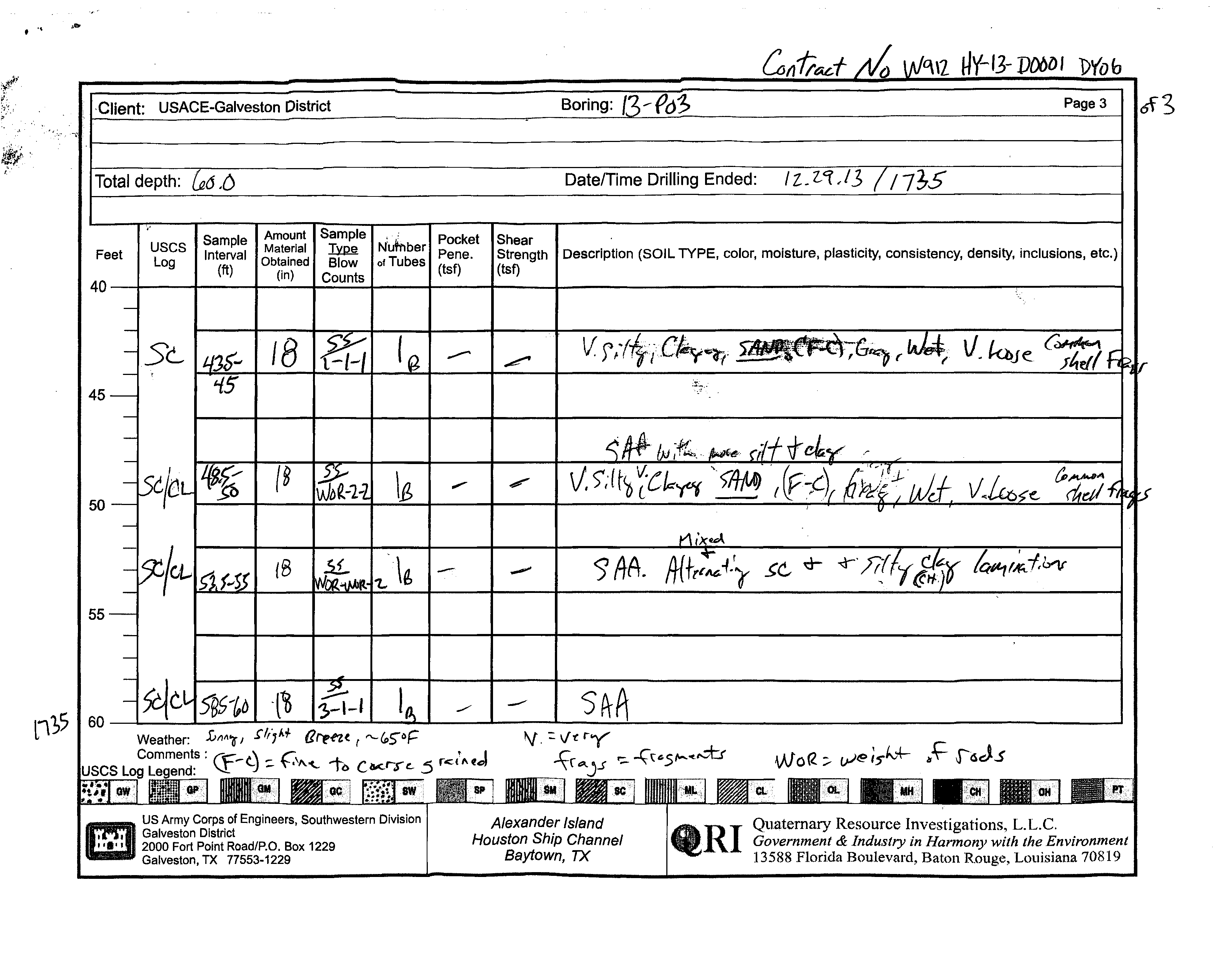
Total depth:
,()
Date/Time Drilling Ended:
uses
Log
Sample Amount
pie, ;
Pocket
Interval
Material
~
N'utnber Pene.
Shear
Strength Description (SOIL TYPE, color, moisture, plasticity, consistency, density, inclusions, etc.)
(tsf)
Feet
Obtained
Blow
of Tubes
(tt)
(in)
Counts
(tsf)
40--+---~-----r----r----+----+-----r---~~----------------------------------------------~
45
50
55
US Army Corps of Engineers, Southwestern Division
i Galveston District
'...111
2000 Fort Point Road/P.O. Box 1229
... Galveston, TX 77553-1229
Alexander Island
Houston
Ship Channel
Baytown, TX
Quaternary Resource Investigations,
L.L.c.
Government
&
Industry in Harmony with the Environment
13588 Florida Boulevard, Baton Rouge, Louisiana
70819
17
35
34
34
33
85
90
97
59
17
97
50
120
124
131
12
19
26
52
61
17
45
84
70
47
45
64
68
72
56
62
0.45
0.2-0.45
0.45
0.4
0.2
0.25
0.35
0.4
0.4
0.4
0.75
0.25
0-0.75
0
0
0.75
0
0
0.25
0
0
18
0
13
9
15
14
0
13
0
10
18
18
18
0
18
16
0
18
ST
NR
SS
ST
ST
ST
NR
SS
NR
SS
ST
ST
SS
NR
SS
ST
NR
SS
3-3-4
(7)
6-4-5
(9)
1-1-1
(2)
2-2-3
(5)
0-2-2
(4)
1-1-1
(2)
Silty SAND; fine to coarse grained, light
orangish brown, moist, very loose
clayey
not clayey
CLAY; reddish brown to dark gray, moist,
medium plasticity, soft
black to dark gray, high plasticity, very soft
to soft
Clayey SAND; fine to coarse grained, light
orangish brown, moist, very loose
wet, light gray, loose, with common shell
fragments
CLAY; brownish gray to black, moist, high
plasticity, very soft
dark gray
Very silty SAND; fine to medium grained,
light brownish gray, wet loose, with
abundant silty clay laminations
Silty CLAY; brownish gray to black, moist,
high plasticity, soft
Very silty SAND; fine to medium grained,
light brown, wet, loose, slightly clayey
CLAY; black to dark gray, moist, high
plasticity, soft
black
Silty SAND; fine to medium grained, very
light gray, wet, very loose
SM
CH
SC
CH
SM
CH
SM
CH
SM
CH
0.33
0.96
6
3
8
12
DRILLING CONTRACTOR
QRI
LOGGED BY
Eddie Ficker
GROUND ELEVATION
23.8203 ft
NORTHING
13828684 ft
WEATHER
sunny, 65, slight breeze
GROUND WATER LEVEL
HOLE SIZE
8.25 inches
EASTING
3224485 ft
DRILLING METHOD
Hollow Stem Auger
DRILLING RIG MAKE/MODEL
Mobile B57 on Gemco Articulated Platform
TOTAL DEPTH
60 ft
DATE STARTED
12/29/2013 12:30:00 PM
COMPLETED
12/29/2013 5:35:00 PM
AT TIME OF DRILLING
12.00 ft / Elev 11.82 ft
24 HOURS AFTER DRILLING
10.70 ft / Elev 13.12 ft
(Continued Next Page)
PLASTIC
LIMIT
PLASTICITY
INDEX
MINUS #200 SIEVE
CONTENT (%)
LIQUID
LIMIT
ATTERBERG
LIMITS
MOISTURE
CONTENT (%)
DRY UNIT WT.
(pcf)
FIELD TORVANE
(tsf)
POCKET PEN.
(tsf)
RECOVERY
(in)
SAMPLE TYPE
DEPTH
(ft)
0
5
10
15
20
25
30
35
SPT BLOW
COUNTS
(N VALUE)
GRAPHIC
LOG
MATERIAL DESCRIPTION
USCS SYMBOL
COMPRESSIVE
STRENGTH (tsf)
FAILURE
STRAIN (%)
CONFINING
PRESSURE (psi)
PAGE 1 OF 2
BORING NUMBER 13-P03
CLIENT
USACE-Galveston District
PROJECT NUMBER
W912HY-13-D-0001-DY06
PROJECT NAME
Alexander Island
PROJECT LOCATION
Alexander Island, Baytown, TX
COPY OF PEGGY LAKE GEOTECH BH - PEGGY LAKE TEMPLATE.GDT - 4/4/14 15:04 - F:\QRI DATA\TECHNICAL\JOBS (CURRENT)\ACE - GALVESTON\2012-12-20 GEOTECHNICAL CONTRACT\TASK ORDER DY06 2013-09-10 ALEXANDER ISLAND\DELIVERABLES\ALEXANDE
Quaternary Resource Investigations, LLC
13588 Florida Boulevard
Baton Rouge, LA 70820
Telephone: 225-292-1400
Fax: 225-292-1404
54
58
67
27
22
23
28
25
17
0.75
0
18
0
18
0
18
0
18
0
18
ST
NR
SS
NR
SS
NR
SS
NR
SS
NR
SS
0-0-1
(1)
1-1-1
(2)
0-2-2
(4)
0-0-2
(2)
3-1-1
(2)
CLAY; black to dark gray, moist, high
plasticity, soft, with common fine sand
laminations
(continued)
gray
Silty CLAY; gray, wet, loose, with common
shell fragments and fine to coarse grained
sand
sand is fine to medium grained, slightly
clayey
Silty CLAY; gray, wet, with common shell
fragments and fine to coarse grained, very
loose sand
increasing silt and clay
Alternating and mixed clayey SAND (SC)
and silty CLAY (CL) laminations
Bottom of borehole at 60.0 feet.
CH
CL-
ML
CL
PLASTIC
LIMIT
PLASTICITY
INDEX
MINUS #200 SIEVE
CONTENT (%)
LIQUID
LIMIT
ATTERBERG
LIMITS
MOISTURE
CONTENT (%)
DRY UNIT WT.
(pcf)
FIELD TORVANE
(tsf)
POCKET PEN.
(tsf)
RECOVERY
(in)
SAMPLE TYPE
DEPTH
(ft)
35
40
45
50
55
60
SPT BLOW
COUNTS
(N VALUE)
GRAPHIC
LOG
MATERIAL DESCRIPTION
USCS SYMBOL
COMPRESSIVE
STRENGTH (tsf)
FAILURE
STRAIN (%)
CONFINING
PRESSURE (psi)
PAGE 2 OF 2
BORING NUMBER 13-P03
CLIENT
USACE-Galveston District
PROJECT NUMBER
W912HY-13-D-0001-DY06
PROJECT NAME
Alexander Island
PROJECT LOCATION
Alexander Island, Baytown, TX
COPY OF PEGGY LAKE GEOTECH BH - PEGGY LAKE TEMPLATE.GDT - 4/4/14 15:04 - F:\QRI DATA\TECHNICAL\JOBS (CURRENT)\ACE - GALVESTON\2012-12-20 GEOTECHNICAL CONTRACT\TASK ORDER DY06 2013-09-10 ALEXANDER ISLAND\DELIVERABLES\ALEXANDE
Quaternary Resource Investigations, LLC
13588 Florida Boulevard
Baton Rouge, LA 70820
Telephone: 225-292-1400
Fax: 225-292-1404
3/8 4 10 40 100 200 gravel sand silt clay
sieve
200
C Wc γd
C Wcγd
C φ Wc
C φ c̕φ̕Wcγd
ft
tsf tsf bl/ft % % % % % % % % % % % % % %
% pcf
ksf
% pcf
ksf
% pcf
ksf
º
%
ksf
º
ksf
º
%
pcf
USCS
Symbol
SUMMARY TABLE OF LABORATORY TEST DATA
Unconfined Compression
UU Triaxial Test
CU Triaxial Test
Symbol
Symbol
Symbol
γd
Direct Shear
Symbol
Strenght Tests
Wc
Atterberg Limits
PP
% by weight passing sieve
Client: QRI
Terracon Project # : 92135456
Grain Size Analysis
SPTn
Project Name: Alexander Island
Boring
Depth
LL
PL
PI
Field Tests
TV
0-2
0.75
34
12
22
100
99
99
96
61
1
38
61
CL
17
109
2-4
20
11
4-6
2.0
18
6-8
0
0.04
6
76
23
53 100 100 100 99
84
0
15
84
CH
32 84
0.35 32 84
CH**
8-10
100
96
89
72
0
28
31
41
72
CH*
18
10-12
15
29
12-14
11
100
99
81
64
61
0
39
21
40
61
CH*
25
14-16
5
23
16-18
22
18-20
4
100
100
97
28
0
72
28
SM*
24
20-22
10
51
65
0.32
51
65
CH**
22-24
0.25
0.07
5
73
54
24-26
29
26-28
0
0.25
53
73
28-30
30
30-32
22
100