ALEXANDER ISLAND
BORING SUMMARY SHEET
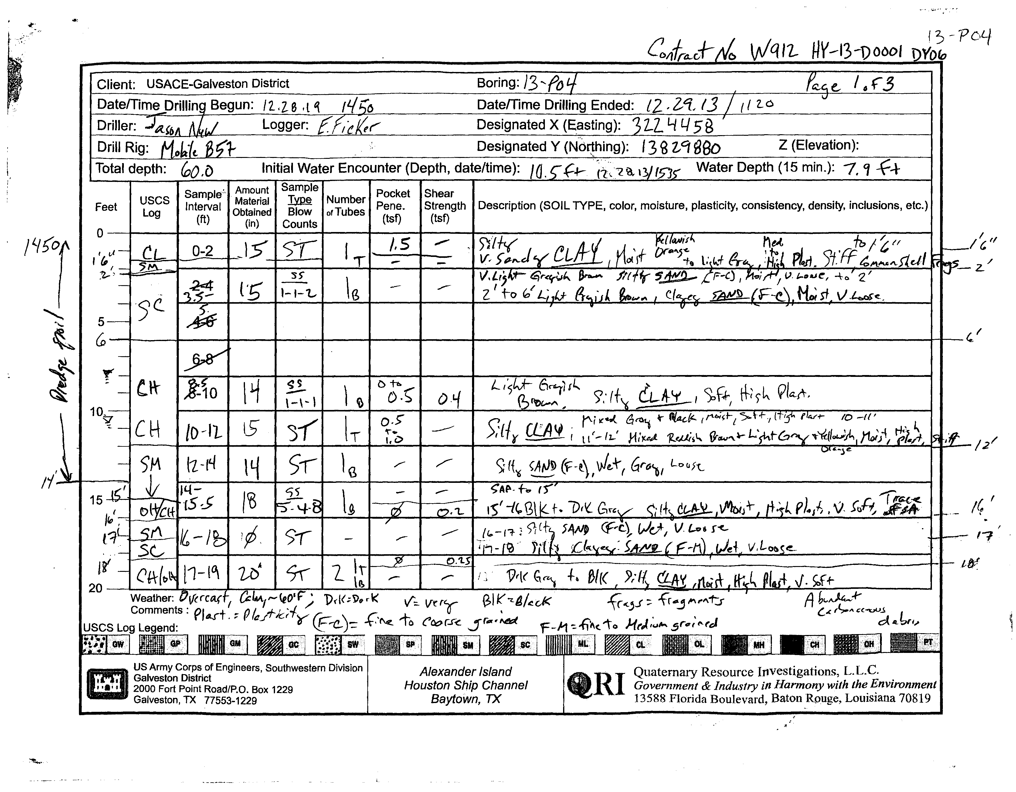
BORING ID:
13-P04
BORING TYPE:
Perimeter Levee
DEPTH:
60'
ELEVATION:
24.00'
X (US SURVEY FT):
3224458.15
Y (US SURVEY FT):
13829880.09
DEPTH TO WATER:
7.9'
~
l,_,_<
,,-
,
:>
i
i,
~-
''I
5
T
"-
"
~
~
~I
Ii'
\\r I
~-oM
•.
I
~
-P
o
4
Client: USACE-Galveston District
Datemme
Driller:
--...,,. ,
'AW
""f
. """,,"
_.
,
Drill Rig:
Mo~it
8
~t-
Designated Y
(N6~hing):
13
g
zPr
~SO
Z (Elevation):
Total
depth:
00,D
Initial Water Encounter (Depth, date/time):
IQ.£
f.r
~~"?
a \
sJ
(t;"'lr:-
Water Depth (15 min.):
I.
'j
Sample"
Amount
Sample
Pocket
Shear
I
uses
Material
:fum
Number
Feet
I Log
Interval
Obtained
Blow
of Tubes
Pene.
Strength Description
(SOIL TYPE, color, moisture, plasticity, consistency, density, inclusions, etc.)
(ft)
(in)
Counts
(tsf)
(tsf)
0
/,5
)'j'lly
t
'f!{f~/j"
t'\e-t
10 I t
1/
I
~
(/
CL
0-2
J5
Sf
IT
,"'-
.,....
.
~,?,,,,J
yeLA:
I
nol\~ {)r~~~9 t;\I..+~"
;Jt£ ?Ln.
51.'ff
~~~AJtcl'
rc;;-
1(,
L /
~
-
-
:z..'
1-
:S5"
,
-
-2c¢
('t;'
-
, 'l. <-
l-I-t..
-5(.
5-
1'_
I
I
I
I
I
I
IJ
G
,I
-.,r
At\\'
j:~o
l~
~~
\
~
()To-~
t.../SM
b~7[L..
~:(f"
{L-A-LI
<),~~I
{i-;)k 9/a./l,
-
C).
o.~
1O,
\
-\-\
~~"'~
IT
0.>
,
,.
. /",i
lC
...{
6~
t-
"iac.t"-
Ir-";~r{
S<-t-r.,
{i~
fl4r'r
10
-({'
"{
CH
/0;11-
lS
)-(
'r..
----
Xl!r
etA
'1
r II
(-/1-'
Ht',w,
~«.Jis"
(y...,,,
r
L'r"-'
\.;1"::X: Tl'L{I-;'''V
1Of)',e.'./'f,
~'!:
I"
C>
/2/
bt~-\~
,..
/"
~H~ ~ (~'l\,v1e;~'(
GrOll
loul'L
"'.
,
-
I "... .
\
I
/1
I
'~
I
!~
f
..w..--l?
.. '
,:)c..,.,
\
o.'t.S
~
taf
If
C~{f1~
l1-1"
7'r
1
\i
-
-
I:
1/,\(
G
lUI)' .,
~,
_,
'
v'~"
20
Weather:
(j(rca..(
{
1M,"'\tO'F';
D(((;:~q.1<
V=- V'Cfy
e.1k' ....
M~d<
-(r-oC.j..f;'
f'r...
..,"""'I\..,...s
Comments'
n,
t II
'+-'
.-!-
r:..I-
0,
.
'.
I
: . r- A.J .
~
v Ie..! K-f
y
(f-:-c..
)=
~:I'.<.
'1 ()
('eorf<. Sr"".N!Jd
'F-M
-=-.nl\<.
1"0
Mr,J
'W~ ~r
..(
....
(~
i... ,
?..
'I
US Army Corps of Engineers, Southwestern DiviSion
Galveston District
2000 Fort Point Road/P.O. Box 1229
Galveston, TX 77553-1229
Alexander Island
Houston
Ship Channel
Baytown, TX
Quaternary Resource Investigations,
L.
L.
C.
Government
&
Industry in Harmony with the Environment
13588 Florida Boulevard, Baton Rouge, Louisiana 70819
24.0011'
20
35
.<~~~
. ,;':1>
USA4E-Galveston Di.$l:i"ict
Amount
Material
Obtained
(in)
/IJ
9f
fro
5,
sT
l-r
I,
1-
I
US AilTly,Corps of Engineers, Southwestern Division
Galveston District
2000
Fort Point Road/P.O. Box 1229
. Galveston, tx 77553-1229
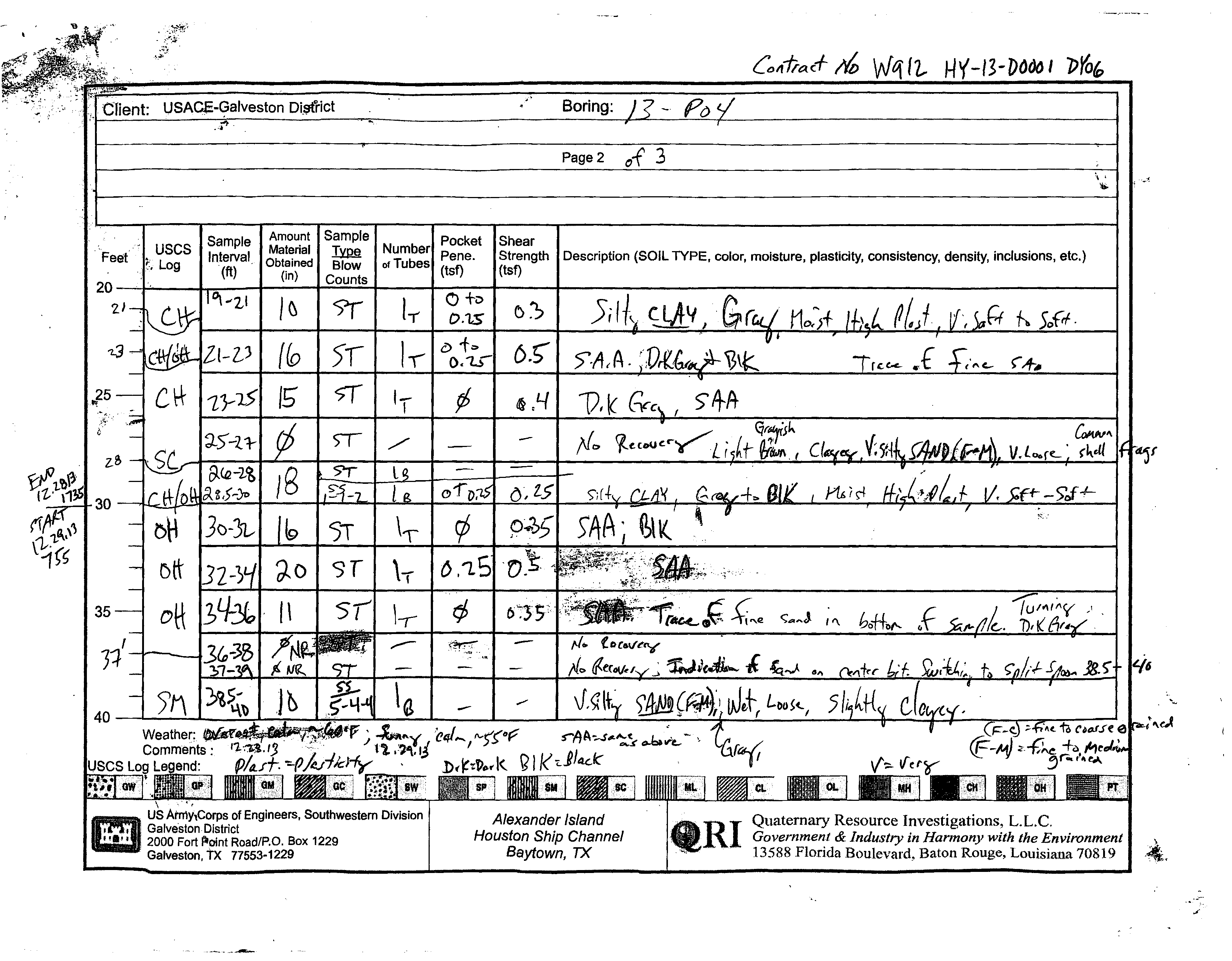
Boring:
Page 2
3
Pocket
Shear
Pene.
Strength
Description (SOIL TYPE, color, moisture, plasticity, consistency, density, inclusions, etc.)
(tst)
(tst)
(;) +"
O~
O.tS
b
t",
6.~
>ltA ..
o.
¢
~
,4
v,k
he
tit>
Alexander Island
Houston Ship Channel
Baytown,
TX
Quaternary Resource Investigations,
L.L.c.
Government
&
Industry in Harmony with the Environment
13588 Florida Boulevard, Baton Rouge, Louisiana 70819
..
'
"-
f
,
~.:',.
."-.:..t
~.~
..
Client: USACE;.Galveston District
Total depth:
...•"..
Shear
Boring:
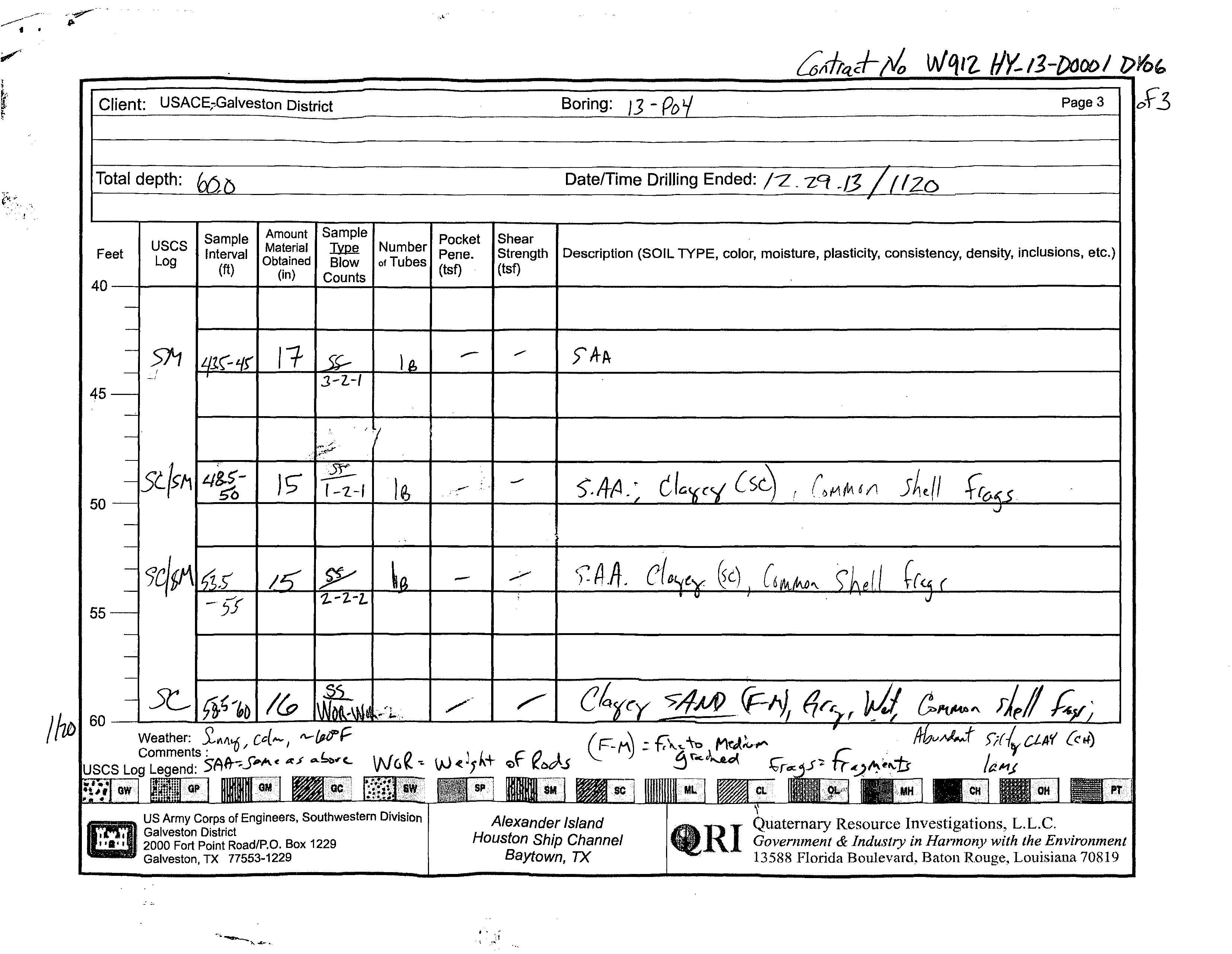
}3 -
Po
Page 3
DatelTime Drilling Ended: /2 . zq
J3
IZo
USCS
Sample IAmount I Sample
Log
Interval
Material
Jmg
Number Pocket
(ft)
Obtained
BI
P
40
I
(" )
ow
of Tubes
ene.
Feet
Strength IDescription (SOIL TYPE, color, moisture, plastiCity, consistency, density, inclusions, etc.)
45
50
55
//w160
(tsf)
In
Counts
(tsf)
I
I
S11
11I1r"_Llt"
I
11- I <"c
I
I
1\
I
-
I
....-
-1
-4
""
.,
/.
,5Cfl1ll/~-tlS-~'II~
1.,-1
~
5t,1~~"hbl/~
Weather: 1MI;('
eel
f\..-1.H>f':.
....."''t.'
~.>
/'
/.-
/"'
T
I )'A-A
I
5.,4A.:
cJ;~cy
CSc.)
!
(olldMI1
5Ae.{1
fro
Cb
vc'
Comments:
v
/
-
I
"., ,...
I::;p_:,-
-g Leaend:
5AI>J-;SP-A~
IItJ
~t-
,.j
W6~ ~ W<J,.~+
,.,f
eorJ.s
0""-M);
f;~~e:w,.
:..J
Wcic
US Army Corps of Engineers, Southwestern DMslon
Galveston District
2000 Fort Point Road/P.O. Box 1229
Galveston, TX 77553-1229
<:'i. _____........
~
Alexander Island
Houston
Ship Channel
Baytown, TX
...
H
\
.....
Resource Investigations,
L.L.c.
Government
&
Industry in Hannony with the Environment
13588 Florida Boulevard, Baton Rouge, Louisiana
70819
1
B
11
35
30
37
30
16
77
83
112
88
38
97
8
98
27
112
113
149
118
21
19
39
74
20
35
90
38
84
79
70
71
67
55
73
53
54
58
0.4
0.2
0.25
0.3
0.5
0.4
0.25
0.35
0.5
1.5
0-0.5
0.5-1.0
0
0
0-0.25
0-0.25
0
0-0.25
0
0.25
15
0
15
0
14
15
14
18
0
20
10
16
15
0
14
0
18
16
20
ST
NR
SS
NR
SS
ST
ST
SS
NR
ST
ST
ST
ST
NR
ST
NR
SS
ST
ST
1-1-2
(3)
1-1-1
(2)
5-4-8
(12)
1-1-2
(3)
Silty very sandy CLAY; yellowish orange to
light gray, moist, medium to high plasticity,
stiff, with common shell fragments
Silty SAND; fine to coarse grained, very light
grayish brown, moist, very loose
Clayey SAND; fine to coarse grained, light
grayish brown, moist, very loose
CLAY; light grayish brown, soft, high
plasticity
mixed gray and black, moist
mixed reddish brown/light gray/yellowish
orange, stiff
SAND with SILT; fine to coarse grained,
gray, wet, loose
Silty CLAY, black to dark gray, moist, high
plasticity, very soft, trace of sand
Silty SAND; fine to coarse grained, wet, very
loose
Silty clayey SAND; fine to medium grained,
wet, very loose
CLAY; dark gray to black, moist, high
plasticity, very soft, abundant carbonaceous
debris
gray, very soft to soft, no carbonaceous
debris
dark gray and black (CH/OH), trace of fine
sand
dark gray
Clayey SAND; fine to medium grained, light
grayish brown, very moist, very loose, with
common shell fragments
CLAY; gray to black, moist, high plasticity,
very soft to soft
black
CL
SM
SC
CH
SP-
SM
CH
SM
SC
CH
SC
CH
0.44
0.45
0.68
0.69
0.65
15
1
4
2
3
0
11
0
12
0
DRILLING CONTRACTOR
QRI
LOGGED BY
Eddie Ficker
GROUND ELEVATION
24.0011 ft
NORTHING
13829880 ft
WEATHER
cloudy to sunny, 60 to 55, calm
GROUND WATER LEVEL
HOLE SIZE
8.25 inches
EASTING
3224458 ft
DRILLING METHOD
Hollow Stem Auger
DRILLING RIG MAKE/MODEL
Mobile B57 on Gemco Articulated Platform
TOTAL DEPTH
60 ft
DATE STARTED
12/28/2013 2:50:00 PM
COMPLETED
12/29/2013 11:20:00 AM
AT TIME OF DRILLING
10.50 ft / Elev 13.50 ft
24 HOURS AFTER DRILLING
7.90 ft / Elev 16.10 ft
(Continued Next Page)
PLASTIC
LIMIT
PLASTICITY
INDEX
MINUS #200 SIEVE
CONTENT (%)
LIQUID
LIMIT
ATTERBERG
LIMITS
MOISTURE
CONTENT (%)
DRY UNIT WT.
(pcf)
FIELD TORVANE
(tsf)
POCKET PEN.
(tsf)
RECOVERY
(in)
SAMPLE TYPE
DEPTH
(ft)
0
5
10
15
20
25
30
35
SPT BLOW
COUNTS
(N VALUE)
GRAPHIC
LOG
MATERIAL DESCRIPTION
USCS SYMBOL
COMPRESSIVE
STRENGTH (tsf)
FAILURE
STRAIN (%)
CONFINING
PRESSURE (psi)
PAGE 1 OF 2
BORING NUMBER 13-P04
CLIENT
USACE-Galveston District
PROJECT NUMBER
W912HY-13-D-0001-DY06
PROJECT NAME
Alexander Island
PROJECT LOCATION
Alexander Island, Baytown, TX
COPY OF PEGGY LAKE GEOTECH BH - PEGGY LAKE TEMPLATE.GDT - 4/4/14 15:04 - F:\QRI DATA\TECHNICAL\JOBS (CURRENT)\ACE - GALVESTON\2012-12-20 GEOTECHNICAL CONTRACT\TASK ORDER DY06 2013-09-10 ALEXANDER ISLAND\DELIVERABLES\ALEXANDE
Quaternary Resource Investigations, LLC
13588 Florida Boulevard
Baton Rouge, LA 70820
Telephone: 225-292-1400
Fax: 225-292-1404
32 86 99
19
43
52
67 118
23
18
24
23
31
11
0
0.35
58
0
10
0
17
0
15
0
15
0
16
ST
NR
SS
NR
SS
NR
SS
NR
SS
NR
SS
5-4-4
(8)
3-2-1
(3)
1-2-1
(3)
2-2-2
(4)
0-0-2
(2)
CLAY; gray to black, moist, high plasticity,
very soft to soft
(continued)
trace of fine sand and turning dark gray
Very silty SAND; fine to medium grained,
gray, wet, loose, slightly clayey
Clayey SAND; fine to medium grained, gray,
wet, loose, with common shell fragments
Silty CLAY; gray, wet, with common shell
fragments and fine to medium grained sand,
loose
Bottom of borehole at 60.0 feet.
CH
SM
SC
CL
PLASTIC
LIMIT
PLASTICITY
INDEX
MINUS #200 SIEVE
CONTENT (%)
LIQUID
LIMIT
ATTERBERG
LIMITS
MOISTURE
CONTENT (%)
DRY UNIT WT.
(pcf)
FIELD TORVANE
(tsf)
POCKET PEN.
(tsf)
RECOVERY
(in)
SAMPLE TYPE
DEPTH
(ft)
35
40
45
50
55
60
SPT BLOW
COUNTS
(N VALUE)
GRAPHIC
LOG
MATERIAL DESCRIPTION
USCS SYMBOL
COMPRESSIVE
STRENGTH (tsf)
FAILURE
STRAIN (%)
CONFINING
PRESSURE (psi)
PAGE 2 OF 2
BORING NUMBER 13-P04
CLIENT
USACE-Galveston District
PROJECT NUMBER
W912HY-13-D-0001-DY06
PROJECT NAME
Alexander Island
PROJECT LOCATION
Alexander Island, Baytown, TX
COPY OF PEGGY LAKE GEOTECH BH - PEGGY LAKE TEMPLATE.GDT - 4/4/14 15:04 - F:\QRI DATA\TECHNICAL\JOBS (CURRENT)\ACE - GALVESTON\2012-12-20 GEOTECHNICAL CONTRACT\TASK ORDER DY06 2013-09-10 ALEXANDER ISLAND\DELIVERABLES\ALEXANDE
Quaternary Resource Investigations, LLC
13588 Florida Boulevard
Baton Rouge, LA 70820
Telephone: 225-292-1400
Fax: 225-292-1404
3/8 4 10 40 100 200 gravel sand silt clay
sieve
200
C Wc γd
C Wcγd
C φ Wc
C φ c̕φ̕Wcγd
ft
tsf tsf bl/ft % % % % % % % % % % % % % %
% pcf
ksf
% pcf
ksf
% pcf
ksf
º
%
ksf
º
ksf
º
%
pcf
USCS
Symbol
SUMMARY TABLE OF LABORATORY TEST DATA
Unconfined Compression
UU Triaxial Test
CU Triaxial Test
Symbol
Symbol
Symbol
γd
Direct Shear
Symbol
Strenght Tests
Wc
Atterberg Limits
PP
% by weight passing sieve
Client: QRI
Terracon Project # : 92135456
Grain Size Analysis
SPTn
Project Name: Alexander Island
Boring
Depth
LL
PL
PI
Field Tests
TV
0-2
1.5
21
2-3.5
3.5-5
3
27
11
16
99
98
98
83
38
2
60
38
SC
19
5-8.5
8.5-10
0-0.5
0.4
2
100
100
98
97
0
3
26
70
97
CH*
39
Complete Sieve test not assigned but it was performed with hydrometer.
10-12
0.5-1.0
74
55
0.44
74
55
CH**
12-14
100
100
90
8
0
92
8
SP-SM*
20
14-16
0
0.2
12
35
16-18
17-19
0
0.25
90
19-21
0-0.25
0.3
112
35
77
100
100
98
0
2
15
83
98
CH*
38
73
0.45
38
73
CH**
21-23
0-0.25
0.5
113
30
83
CH*
84
53
0.68
84
53
CH**
23-25
0
0.4
149
37
112
CH*
79
54
0.69
79
54
CH**
25-28
26-28
28-28.5
28.5-30
0-0.25
0.25
3
70
30-32
0
0.35
118
30
88