Under the drawing toolbar
select "Draw", then "Snap", then "To Grid"
Paste the pictrues into A1, G1, A17, and G17
Resize the height to 3"
For the next page, paste the picture in the next cell
down from the bottom of the bottom two pictures.
There are six pages formatted this way.
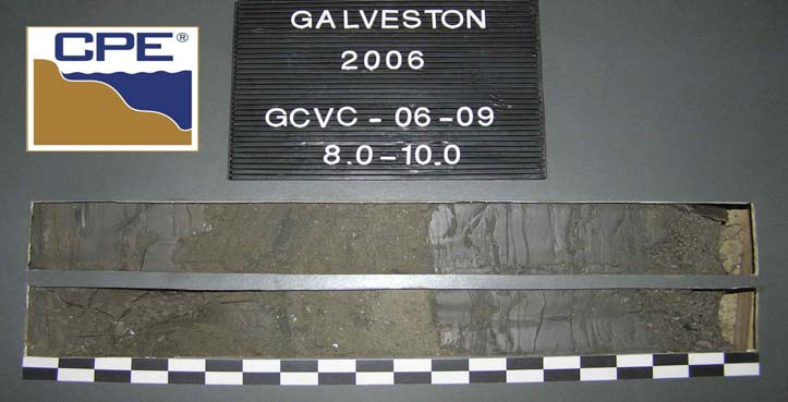
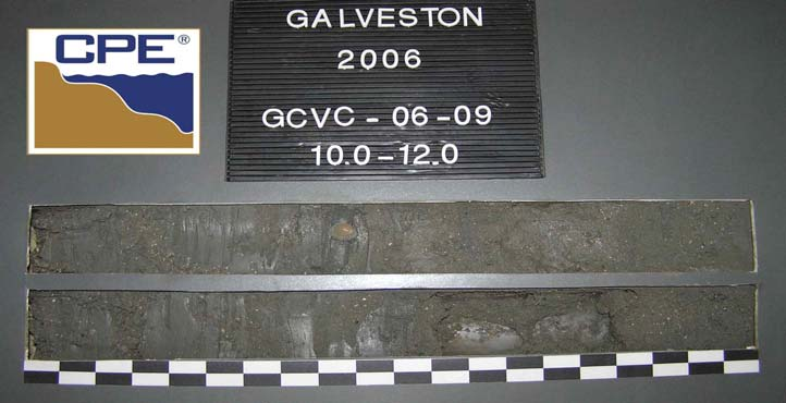
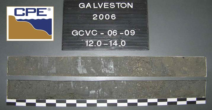
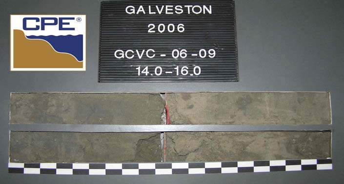
LOCATION COORDINATES
MLLW
17. TOTAL RECOVERY FOR BORING
16. ELEVATION TOP OF BORING
INSTALLATION
DIVISION
STARTED
VERTICAL
INCLINED
FLORIDA DEP ROSS GALVESTON_VIBRACORES_2006.GPJ FL DEP ROSS.GDT 12/14/06
14. ELEVATION GROUND WATER
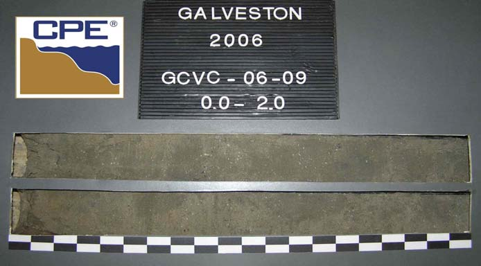
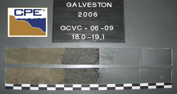
SAND,
fine
grained,
quartz,
trace
shell
hash,
trace
silt,
1.0"
clay
layers
@
6.3'
and
7.0',
gray
(5Y-5/1),
(SW).
UNDISTURBED (UD)
DISTURBED
11. MANUFACTURER'S DESIGNATION OF DRILL
10. COORDINATE SYSTEM/DATUM
ML
19.1
Ft.
Texas
South
Central
DRILLING LOG
NAD
1983
10-07-06
17:43
9.2
19.6
13.4
-26.1
8.0
End
of
Boring
No
Recovery.
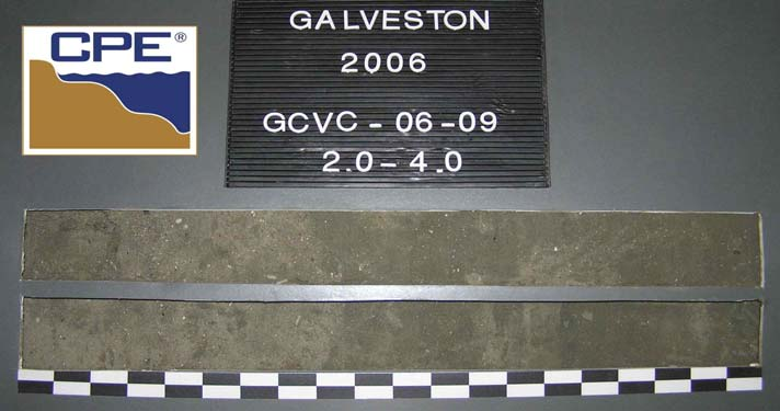
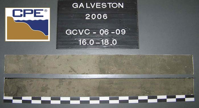
SAND,
fine
grained,
quartz,
trace
shell
hash,
trace
silt,
gray
(5Y-5/1),
(SP-SM).
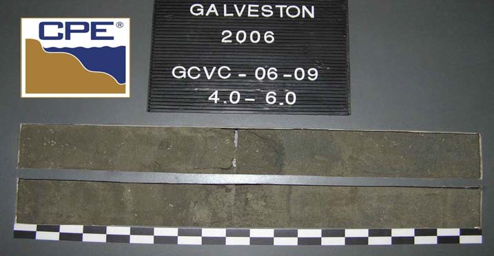
CLAY,
little
shell
hash,
trace
silt,
clay
stiff
to
soft;
2.0"
shell
hash
layers
@
10.0'
and
13.3',
dark
gray
(5Y-4/1),
(CL).
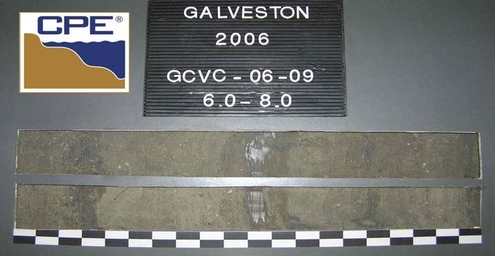
SILT,
some
clay,
little
sand,
trace
shell
hash,
4.0"
clay
layer
@
8.0',
dark
gray
(5Y-4/1),
(ML).
19.1
2
-12.7
-12.7
Ft.
3.0 In.
-20.7
3
-21.9
1
Sample
#3,
Depth
=
16.0'
Mean
(mm):
0.10,
Phi
Sorting:
0.28
Shell
Hash:
0%,
Fines
(230):
7.40%
(SP-SM)
Sample
#2,
Depth
=
8.5'
Mean
(mm):
0.11,
Phi
Sorting:
0.65
Shell
Hash:
0%,
Fines
(230):
84.37%
(ML)
Sample
#1,
Depth
=
2.0'
Mean
(mm):
0.14,
Phi
Sorting:
0.94
Shell
Hash:
2%,
Fines
(230):
2.61%
(SW)
-32.3
-31.8
15. DATE BORING
DEPTH
(ft)
ELEV.
(ft)
CLASSIFICATION OF MATERIALS
Depths and elevations based on measured values
JUN
04
MODIFIED
FOR
THE
FLORIDA
DEP
JUN
02
BOX OR
SAMPLE
Alpine
Ocean
Seismic
Survey,
Inc.
0.0
OF 1 SHEETS
19.6
Ft.
8. TOTAL DEPTH OF BORING
7. DEPTH DRILLED INTO ROCK
CONTRACTOR FILE NO.
18. SIGNATURE AND TITLE OF INSPECTOR
X = 3,331,560 Y = 13,690,909
REMARKS
Boring
Designation
%
REC.
LEGEND
GCVC-06-09
SHEET 1
0
5
10
15
20
25
SAJ
FORM
1836
6. THICKNESS OF OVERBURDEN
0.0 Ft.
COMPLETED
AUTO HAMMER
MANUAL HAMMER
Texas
Geotechnical
Sand
Search
Galveston
County
Texas
GCVC-06-09
BEARING
10-07-06
17:40
1. PROJECT
0.0 Ft.
2. BORING DESIGNATION
3. DRILLING AGENCY
5. DIRECTION OF BORING
DEG. FROM
VERTICAL
13. TOTAL NUMBER CORE BOXES
12. TOTAL SAMPLES
9. SIZE AND TYPE OF BIT
Charles
Dill
HORIZONTAL
VERTICAL
4. NAME OF DRILLER
1.00
0.50
1.00
35
3.66
3.41
0.35
0.33
0.71
0.50
25
3.31
3.08
0.44
0.33
3.71
0.00
18
2.96
2.75
0.58
0.54
1.41
-0.50
14
2.38
2.21
3/4"
0.35
0.29
35.07
32.64
0.13
3.00
120
9.88
9.20
5.38
5.01
0.18
2.50
80
0.30
4.19
0.32
0.27
0.25
2.00
60
4.21
3.92
0.23
0.21
0.35
1.50
45
3.98
2.00
4.50
0.00
0.00
0.00
0.00
0.00
8.00
-3.00
5/16"
0.00
0.00
0.00
0.00
11.31
0.47
7/16"
5.66
0.00
0.00
0.00
16.00
-4.00
5/8"
0.00
0.00
0.00
0.00
19.03
-4.25
-3.50
-2.00
-1.00
10
1.91
1.77
0.76
0.71
2.83
-1.50
7
1.15
1.06
0.23
3.5
4.00
-2.50
5
0.92
0.85
0.24
0.22
4.76
-2.25
4
0.68
0.63
0.68
0.63
170
0.21
0.13
Project
Name:
Texas
Geotechnical
Sand
Search
Sample
Name:
GCVC-06-09
#1
Analysis
Date:
10-18-06
Analyzed
By:
MC
0.22
93.06
Phi
84
2.59
Phi
75
2.72
Phi
50
3.05
Phi
25
3.32
Phi
16
3.42
Phi
5
3.67
Mean
Phi
2.84
41.84
#200
-
3.53
#230
-
2.61
Munsell:
Northing (ft):
-14.7
MLLW
GRANULARMETRIC REPORT GALVESTON_VIBRACORES_2006.GPJ FL DEP ROSS.GDT 12/14/06
Shell Hash (%):
2
Fines (%):
Moment
Statistics
Depths
and
elevations
based
on
measured
values
Easting (ft):
Mean
mm
0.14
Phi
95
2.05
90.98
Coordinate System:
Sieve Loss (%):
Pan Retained (g):
Wash Weight (g):
Organics (%):
Carbonates (%):
Sorting
0.94
96.47
Kurtosis
20.89
Grams
Retained
Sieve
Size
(Millimeters)
Sieve
Size
(Phi)
97.39
90.64
0.92
0.86
0.06
Cum. Grams
Retained
230
C.
%
Weight
Retained
89.78
4.61
4.29
0.07
3.75
200
91.86
85.49
46.91
43.65
0.09
3.50
Coastal
Planning
&
Engineering
2481 NW Boca Raton Blvd, Boca Raton
FL 33431
ph (561) 391-8102
fax
(561)
391-9116
4.00
44.95
3,331,560
Granularmetric
Report
Texas
South
Central
13,690,909
% Weight
Retained
Wet - 5Y-5/1
Dry
-
5Y-6/1
Washed
-
5Y-6/1
Skewness
-4.03
Sieve
Number
Dry Weight (g):
Comments:
USCS:
Elevation (ft):
SW
1.00
0.50
1.00
35
0.21
0.15
0.03
0.02
0.71
0.50
25
0.18
0.13
0.06
0.03
0.17
0.00
18
0.14
0.10
0.06
0.04
1.41
-0.50
14
0.08
0.06
3/4"
0.04
0.03
3.52
2.51
0.13
3.00
120
0.86
0.61
0.55
0.39
0.18
2.50
80
0.02
0.22
0.03
0.02
0.25
2.00
60
0.28
0.20
0.04
0.03
0.35
1.50
45
0.24
2.00
0.31
0.00
0.00
0.00
0.00
0.00
8.00
-3.00
5/16"
0.00
0.00
0.00
0.00
11.31
0.08
7/16"
5.66
0.00
0.00
0.00
16.00
-4.00
5/8"
0.00
0.00
0.00
0.00
19.03
-4.25
-3.50
-2.00
-1.00
10
0.00
0.00
0.00
0.00
2.83
-1.50
7
0.00
0.00
0.00
3.5
4.00
-2.50
5
0.00
0.00
0.00
0.00
4.76
-2.25
4
0.00
0.00
0.00
0.00
170
0.00
0.00
Project
Name:
Texas
Geotechnical
Sand
Search
Sample
Name:
GCVC-06-09
#2
Analysis
Date:
10-18-06
Analyzed
By:
ST
1.04
71.33
Phi
84
Phi
75
Phi
50
Phi
25
Phi
16
Phi
5
Mean
Phi
3.21
3.12
#200
-
87.08
#230
-
84.37
Munsell:
Northing (ft):
-21.2
MLLW
GRANULARMETRIC REPORT GALVESTON_VIBRACORES_2006.GPJ FL DEP ROSS.GDT 12/14/06
Shell Hash (%):
0
Fines (%):
Moment
Statistics
Depths
and
elevations
based
on
measured
values
Easting (ft):
Mean
mm
0.11
Phi
95
3.05
12.18
Coordinate System:
Sieve Loss (%):
Pan Retained (g):
Wash Weight (g):
Organics (%):
Carbonates (%):
Sorting
0.65
12.92
Kurtosis
20.81
Grams
Retained
Sieve
Size
(Millimeters)
Sieve
Size
(Phi)
15.63
11.14
2.71
1.93
0.06
Cum. Grams
Retained
230
C.
%
Weight
Retained
9.21
2.69
1.92
0.07
3.75
200
10.23
7.29
5.85
4.17
0.09
3.50
Coastal
Planning
&
Engineering
2481 NW Boca Raton Blvd, Boca Raton
FL 33431
ph (561) 391-8102
fax
(561)
391-9116
4.00
4.38
3,331,560
Granularmetric
Report
Texas
South
Central
13,690,909
% Weight
Retained
Wet - 5Y-4/1
Dry
-
5Y-5/1
Washed
-
5Y-5/1
Skewness
-3.27
Sieve
Number
Dry Weight (g):
Comments:
USCS:
Elevation (ft):
ML
1.00
0.50
1.00
35
0.13
0.13
0.01
0.01
0.71
0.50
25
0.12
0.12
0.03
0.02
0.14
0.00
18
0.10
0.10
0.02
0.02
1.41
-0.50
14
0.08
0.08
3/4"
0.02
0.00
3.73
3.54
0.13
3.00
120
0.37
0.36
0.21
0.20
0.18
2.50
80
0.01
0.16
0.01
0.00
0.25
2.00
60
0.16
0.16
0.02
0.02
0.35
1.50
45
0.14
2.00
0.16
0.00
0.00
0.00
0.00
0.00
8.00
-3.00
5/16"
0.00
0.00
0.00
0.00
11.31
0.03
7/16"
5.66
0.00
0.00
0.00
16.00
-4.00
5/8"
0.00
0.00
0.00
0.00
19.03
-4.25
-3.50
-2.00
-1.00
10
0.05
0.05
0.05
0.05
2.83
-1.50
7
0.00
0.00
0.00
3.5
4.00
-2.50
5
0.00
0.00
0.00
0.00
4.76
-2.25
4
0.00
0.00
0.00
0.00
170
0.00
0.21
Project
Name:
Texas
Geotechnical
Sand
Search
Sample
Name:
GCVC-06-09
#3
Analysis
Date:
10-18-06
Analyzed
By:
MC
1.29
94.88
Phi
84
3.09
Phi
75
3.15
Phi
50
3.34
Phi
25
3.54
Phi
16
3.67
Phi
5
Mean
Phi
3.31
3.90
#200
-
10.26
#230
-
7.40
Munsell:
Northing (ft):
-28.7
MLLW
GRANULARMETRIC REPORT GALVESTON_VIBRACORES_2006.GPJ FL DEP ROSS.GDT 12/14/06
Shell Hash (%):
0
Fines (%):
Moment
Statistics
Depths
and
elevations
based
on
measured
values
Easting (ft):
Mean
mm
0.10
Phi
95
3.01
89.36
Coordinate System:
Sieve Loss (%):
Pan Retained (g):
Wash Weight (g):
Organics (%):
Carbonates (%):
Sorting
0.28
89.74
Kurtosis
108.76
Grams
Retained
Sieve
Size
(Millimeters)
Sieve
Size
(Phi)
92.60
87.87
2.86
2.71
0.06
Cum. Grams
Retained
230
C.
%
Weight
Retained
85.16
17.27
16.39
0.07
3.75
200
72.47
68.77
68.37
64.87
0.09
3.50
Coastal
Planning
&
Engineering
2481 NW Boca Raton Blvd, Boca Raton
FL 33431
ph (561) 391-8102
fax
(561)
391-9116
4.00
4.10
3,331,560
Granularmetric
Report
Texas
South
Central
13,690,909
% Weight
Retained
Wet - 5Y-5/1
Dry
-
5Y-6/1
Washed
-
5Y-6/1
Skewness
-6.39
Sieve
Number
Dry Weight (g):
Comments:
USCS:
Elevation (ft):
SP-SM
Symbol
50
5
0.01
5
0.001
5
Elev.
(ft)
1
SIEVE ANALYSIS GALVESTON_VIBRACORES_2006.GPJ FL DEP ROSS.GDT 12/14/06
100
90
80
70
-14.7
USCS
%
Fines
%
Organics
%
Carbonates
Median
Mean
Skew
0.1
Sort
40
100
5
10
5
Kurt
60
30
20
10
0
GCVC-06-09
#1
Fine
-4.03
#200 - 3.53
#230
-
2.61
Project
Name:
Analysis
Date:
Analyzed
By:
Easting
(X,
ft):
Northing
(Y,
ft):
Horizontal
System:
Vertical
System:
Percent Finer By Weight
Medium
Coarse
Fine
Coarse
Sand
3
120
2.5
80
1.5
45
Sample
Information
Sample
3.05
SW
0
100
20.89
Percent Coarser By Weight
0
18
-1.5
7
-3
5/16
10
20
30
40
50
60
70
80
90
-2
5
2.84
0.94
3.75
200
Depths
and
elevations
based
on
measured
values
1
35
4
230