LOG OF
BI
)RING
B.1
1 of 1
CLIENT:
HDRIShiner
Moseley and Associates, Inc.
Rock Engineering & Testing Lab., Inc.
PROJECT:
New East Jetty: Mouth of Colorado River
,
4910 Neptune st.
LOCATION:
Matagorda County, TX
corpus Christi, TX 78405
Telephone: 361 8834555
NUMBER:
G207487
Fax: 3618834711
DATE(S) DRILLED:
07/24/07
-
07/24/07
FIELD DATA
LABORATORY DATA
DRILLING METHOD(S):
z
"
Hollow Stem Auger
0
LIMIT
!;:
c
C
GROUNDWATER INFORMATION:
~~
l-
x
W
z
w
(ij
w
"
D
0:
g!~
l-
e
;;;
u;
w
Z
I-
"
I!
"'
00
0
!
I-
~
0
"
~~~lrl!;
0
;
~~
0
~
N
t='
::>
w
_::>
~
Z
_aoo::~
0:
~
~Q
ci
w
~~~~5
::>
w'"
~
z
:r:
~
I-
D~
'"
""
. EL
~,
I-
a.
~~~~G
'"
::>
: EL + 1.0 NAVD' 88
a.
"
0
>-::>
~
z
w
'"
j/zli':':~@
LL
PL
PI
0:0
JPTION OF STRATUM
D
'"
"
DO.
"
r-
WATER DEPTH= B.S'
5
SS
N=5
23
NP
NP
NP
16
SILTY SAND, brown, wet, loose. (SM)
10
5-1
.'
..
55
N=7
25
Same as above, gray.
..
5-2
'
'
..
55
N=6
Same as above. (SM)
5-3
26
NP
NP
NP
15
15
55
-----
.
-
-_.
.-
-_
.
--
--_.
--
-~------------------------------
~
5-4
N= 12
25
POORLY GRADED SAND, with silt, gray with brown layers, wet,
medium dense.
55
N= 19
27
NP
NP
NP
11
Same as above. (SP-SM)
20
5-5
'.
.-
-_.
.-
-_.
c __
--_.
--
------------------------------
-----
55
N= 13
37
SILTY CLAYEY SAND, dark gray, wet, medium dense.
25
5-6
-----
.
-
-_.
.-
-_
.
---
--_.
--
-------------------------------
55
N=4
27
NP
NP
NP
11
POORLY GRADED SAND, with silt, dark gray, wet, very loose.
30
5-7
(SP-SM)
....
!
55
N=5
29
56
19
37
78
FAT CLAY, with sand, gray, very moist, finm. (CH)
35
5-6
-----
.-
---
.-
-_.
--
--_.
--
-------------------------------
~,
5H
P=2.5
24
104
1.7
SANDY FAT CLAY, brown and gray, very moist, very stiff.
40
5-9
5H
P= 1.75
21
33
16
17
40
CLAYEY SAND, brown and gray, moist, stiff. (SC)
S~10
45
Total Depth of I
'" .45' Below WaterLevel
!-
N - STANDARD PENETRATION TEST RESISTANCE
REMARKS:
Boring location was determined by RETL. Boring operations were performed by a
~
P - POCKET PENETROMETER RESISTANCE
drilling sub-contractor to RETL.
9
T - POCKET TORVANE SHEAR STRENGTH
Coordinates: N 28 35 24.9, W 95 58 58.3
August 27, 2007
HDR
I
Shiner Moseley and Associates, Inc.
RETL Job No.: G207487
PROPOSED NEW EAST JETTY
Mouth of the Colorado River
Matagorda County, Texas
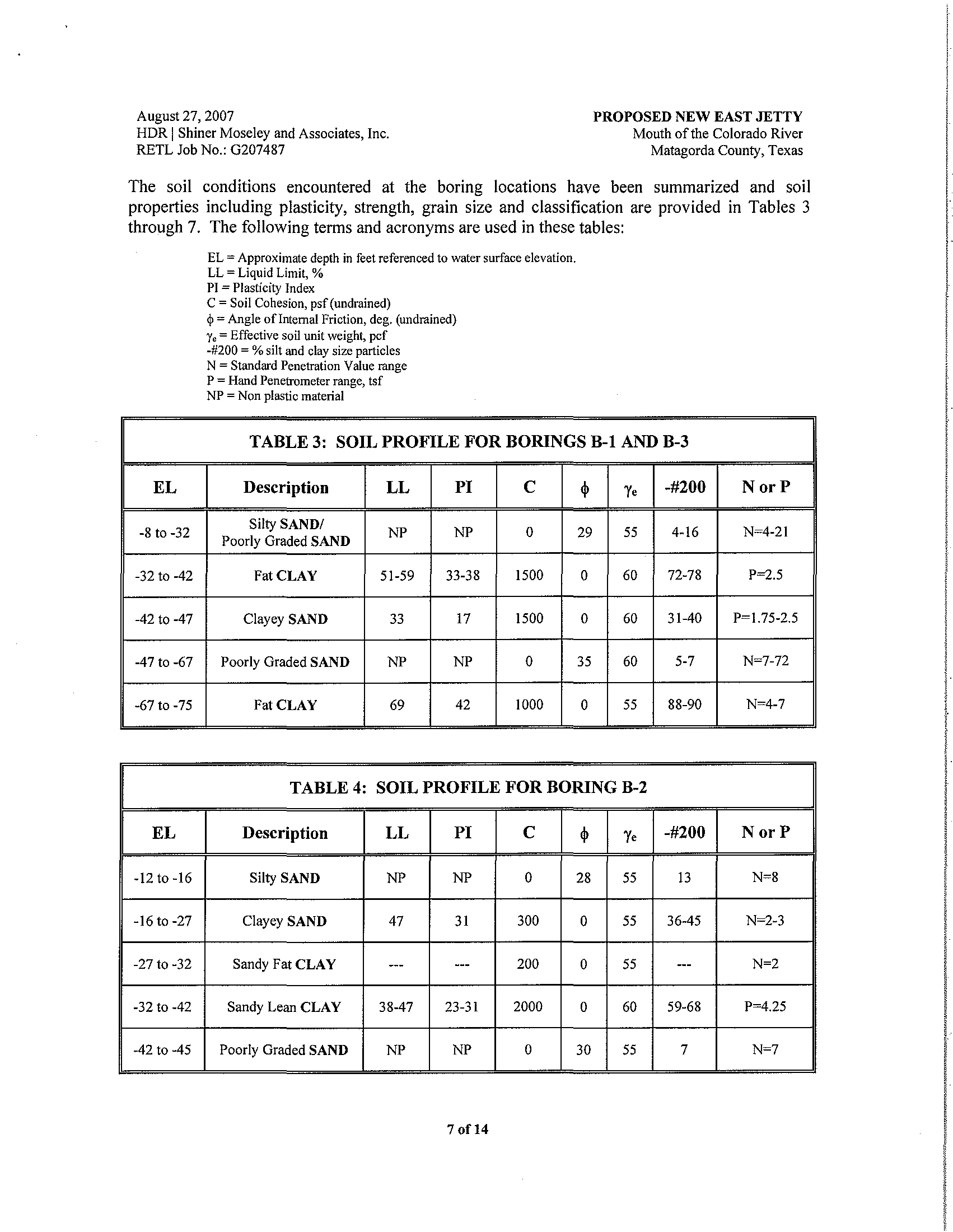
The soil conditions encountered at the boring locations have been summarized and soil
properties including plasticity, strength, grain size and classification are provided
in Tables 3
through
7. The following terms and acronyms are used in these tables:
EL
-8 to -32
-32 to -42
-42 to -47
-47 to -67
-67 to -75
EL
-12to-16
-16to-27
-27 to -32
-32 to -42
-42 to -45
EL
=
Approximate depth in feet referenced to water surface elevation.
LL
=
Liquid Limit, %
PI
= Plasticity Index
C
=
Soil Cohesion, psf (undrained)
~
=
Angle of Internal Friction, deg. (undrained)
Ye
=
Effective soil unit weight, pef
-#200
=
% silt and clay size particles
N
= Standard Penetration Value range
P = Hand Penetrometer range, tsf
NP
=
Non plastic material
TABLE 3: SOIL PROFILE FOR BORINGS B-1 AND B-3
Description
LL
PI
C
4>
y.
-#200
Silty
SANDI
NP
NP
0
29
55
4-16
Poorly Graded SAND
Fat CLAY
51-59
33-38
1500
0
60
72-78
Clayey SAND
33
17
1500
0
60
31-40
Poorly Graded SAND
NP
NP
0
35
60
5-7
Fat CLAY
69
42
1000
0
55
88-90
TABLE 4: SOIL PROFILE FOR BORING B-2
Description
LL
PI
C
4>
y.
-#200
Silty SAND
NP
NP
0
28
55
13
Clayey SAND
47
31
300
0
55
36-45
Sandy Fat CLAY
---
---
200
0
55
---
Sandy Lean CLAY
38-47
23-31
2000
0
60
59-68
Poorly Graded SAND
NP
NP
0
30
55
7
7of14
NorP
N~4-21
P~.5
P~1.75-2.5
N~7-72
N~4-7
NorP
N~8
N~2-3
N~2
P~4.25
N~7
I
1
I
f
I
I'
!
I
I
I
I
I
I
I
I
!
I
I
I
i
I
I
!
I
l
~
August 27, 2007
HDR
I
Shiner Moseley and Associates, Inc.
RETL Job No.: G207487
PROPOSED NEW EAST JETTY
Mouth ofthe Colorado River
Matagorda County, Texas
TABLE 8: GENERALIZED SOIL STRATIGRAPHY FOR
WATERSIDE ZONE A (BORINGS B-1, B-3, B-4, AND B-5)
Approximate
Elevation,
ft
Description
C
cjl
C'
cjl'
y,
(NAVD'88)
-8 to -32
Sand
0
29
0
30
55
-32 to-47
Clay
1500
0
520
25
60
-47
to -67
Sand
0
35
0
35
60
-67 to -75
Clay
1000
0
400
20
55
TABLE 9: GENERALIZED SOIL STRATIGRAPHY FOR
LANDSIDE ZONE B (BORING B-6)
Approximate
Elevation, ft
Description
C
cjl
C'
cjl'
y,
(NAVD'88)
-6to-15