ALEXANDER ISLAND
BORING SUMMARY SHEET
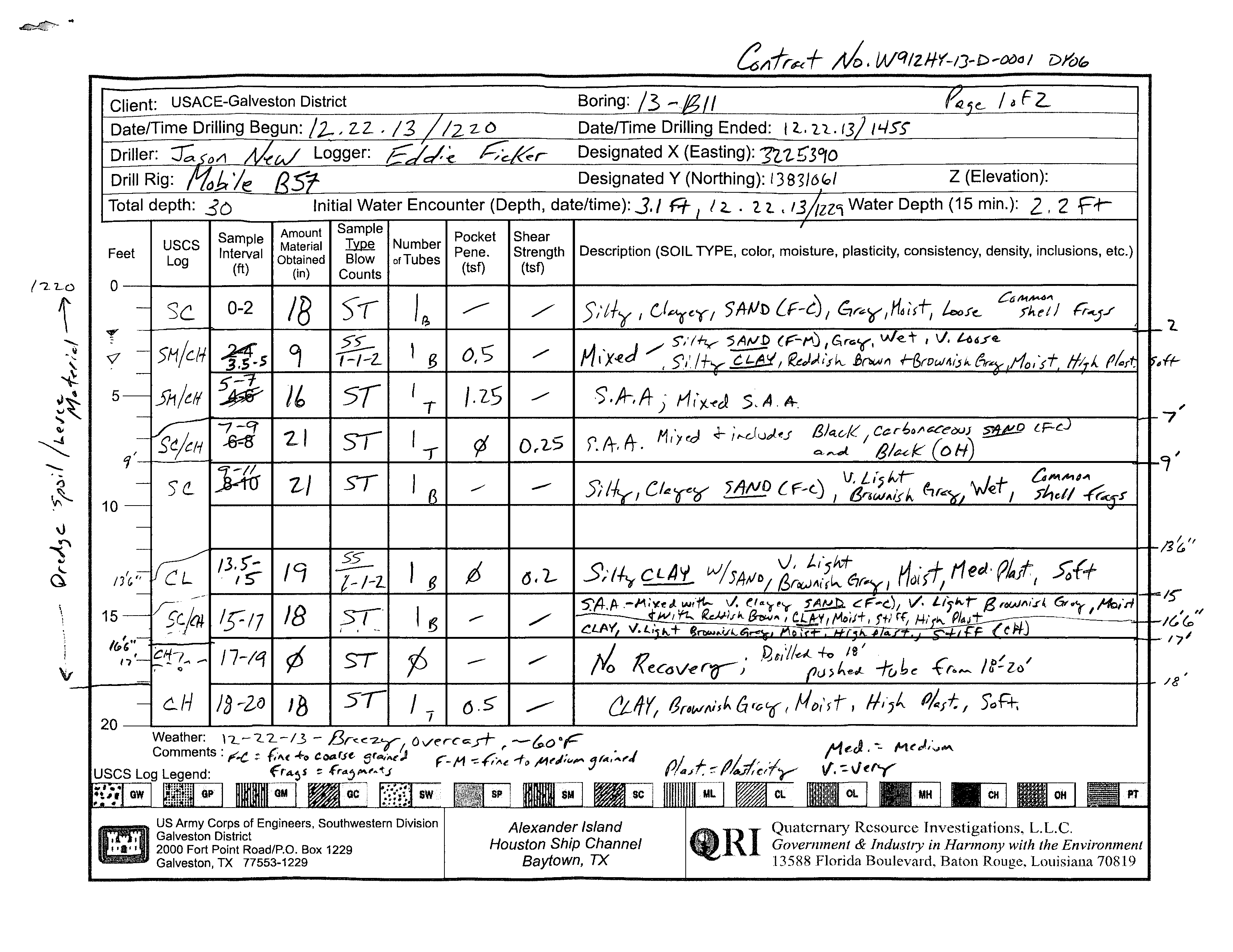
BORING ID:
13-B11
BORING TYPE:
Borrow Source
DEPTH:
60'
ELEVATION:
26.37'
X (US SURVEY FT):
3225389.99
Y (US SURVEY FT):
13831061.05
DEPTH TO WATER:
2.2'
-
Client: USACE-Galveston District
Boring:
Date/Time Drilling Begun:
,
z.z. , /:3
Date/Time
Ended: I
t.
1'2...
Driller: :;;
Designated X (Easting):
Drill Rig:
Designated Y (Northing):
13S3JMQ/
Z (Elevation):
Total depth: .:3
c>
Initial Water Encounter (Depth, date/time): 3./
A-
/
~
.
2.
t .
Water Depth (15 min.): 2, 2
r-r-
Feet
USCS
Log
A
t
Sample
Sample
moun
Pocket
Interval
Material
Type
Number Pene.
Obtained
Blow
of Tubes
Shear
Strength
Description
(SOIL TYPE, color, moisture, plasticity, consistency, density, inclusions, etc.)
(tsf)
(ft)
(in)
Counts
(tsf)
O--+----+----~~~----~--~----_r----~-----------------------------------------------4
2-1
US Army Corps of Engineers, Southwestern Division
Galveston District
2000 Fort Point Road/P.O. Box 1229
Galveston, TX 77553-1229
Alexander Island
Houston Ship Channel
Baytown,
TX
eRI
l'1eJ
.
~ M~J.,·v*,
if.
-=-\l,.ry
Quaternary Resource Investigations,
L.L.c.
Government
&
Industry in Harmony with the Environment
13588 Florida Boulevard, Baton Rouge, Louisiana
70819
B=bag, T=tube
\
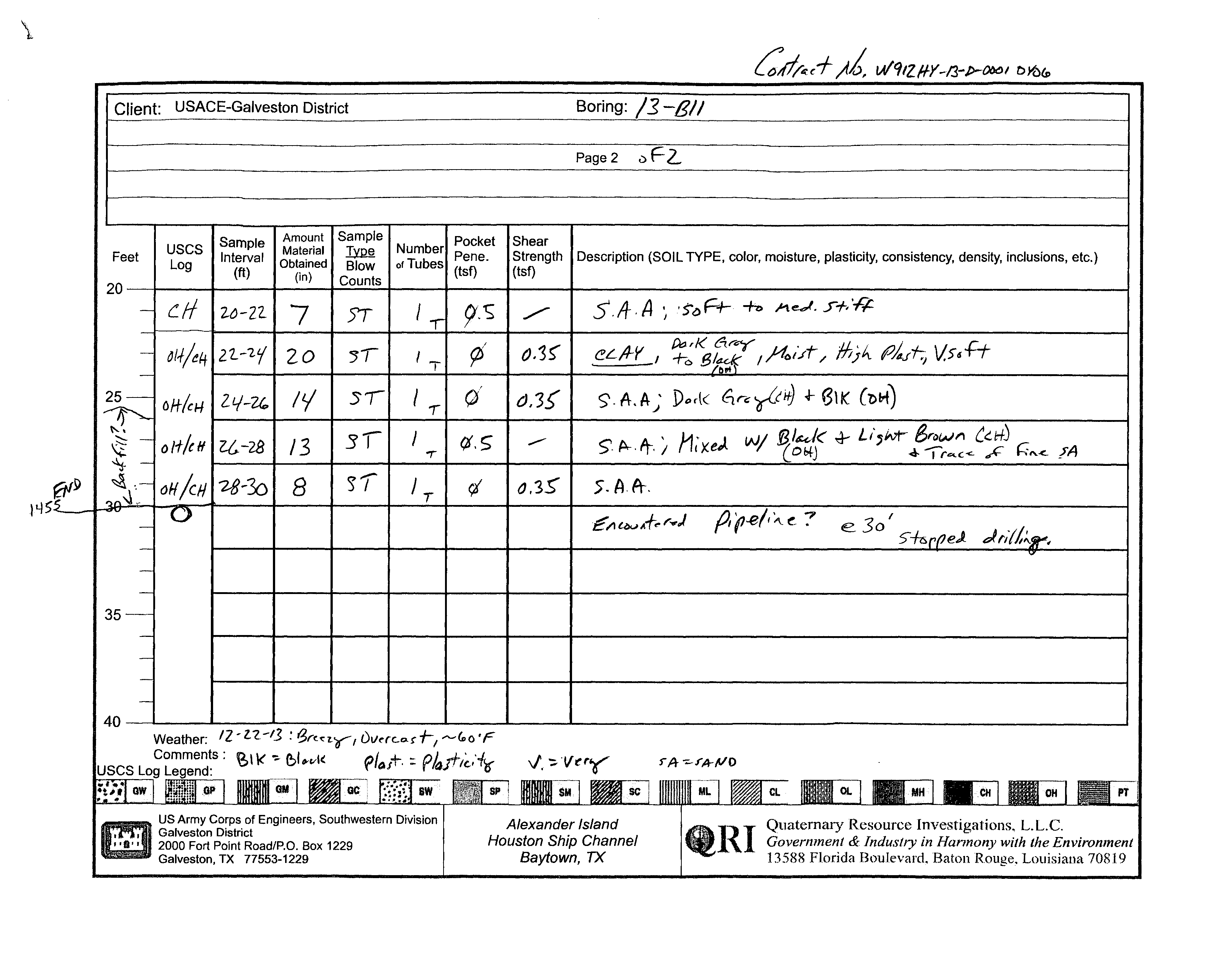
Client:
USACE-Galveston District
Boring:l1-BII
...
Page 2
.)F2..
Sample
Amount
Sample
~~~~:~
Pocket
Shear
Feet
USCS
Interval
Material
llilli
Pene.
Strength
Description
(SOIL TYPE, color, moisture, plasticity, consistency, density, inclusions, etc.)
Log
(ft)
Obtained
Blow
(tst)
(tst)
20
(in)
Counts
-
c.lf
~~-2Z.
7
IT
"
9·~
./"
5'./1" A
~
'S't:>
F+-
+0
I't
e.,f.
..r+,
'R
...
-
~/1/t'+
2'L-'2i
20
~I
'T
rj
(}.3~
eL,4--Y
I
~~~tieyl)40t'./r/
M;;,. f/4rf;
VS6H-
-
25-
oH-ic,.,
Z,-/-2(",
1£/
51
I
.,
(J
(),3{
<;;.
A.
It~·
D"rk
~n:; ~(0
.j- '3\
K
C-ol-t)
~
31
J
~.
p...
Pr.;
!1;xe)
WI
~/uk
.}-
U,M- Brow",
C"HJ
~-
011-/((1
Z&-28
13
(j,S
--
-r
O!+J
..!- 'I
r ....c<-
~
h,,-<.
J"A
~
-
~
.. -
OH/cH
'28-30
8
)/
IT
(,i
O,3S'
5.f:J.ft-.
,.,,..
0
E;'Ill>V
Af..
r ...)
p,
(1.e1
1
~
(:.
?
1£.30
I
-
5"-k.
r
peJ.
dl';(/'~.
-
~
-
-
35 -_.-
-
-
--
-
40
Weather:
IZ-Z:Z.-/j
:gr<qYfi)vac..o.r-r/"-"-~o·F
Comments:
~
I\< ':-
(;1
wl(
USCS Log
?/o,+'
::
Pkfh~/'i?r
V',
-;:.-V~y
1"A
~rllr~O
1~{tf'l
I
r:Wi~l
!
$Ci_6~
us Army Corps of Engineers, Southwestern Division
Alexander Island
.1~I
Quaternruy Resource Investigations.
L.L.c.
Galveston District
2000 Fort Point Road/P.O. Box 1229
Houston Ship Channel
Government
&
IndustfY in Hannony with the Environment
Galveston, TX 77553-1229
Baytown, TX
13588 Florida Boulevard, Baton Rouge, Louisiana 70819
B=bag, T=tube
16
29
35
33
80
46
81
94
49
109
81
17
26
15
26
19
35
32
45
61
66
49
58
51
73
61
69
0.25
0.2
0.35
0.35
0.35
-
0.5
1.25
0
-
0
-
0.5
0.5
0
0
0.5
0
18
0
9
16
21
21
0
19
18
0
18
7
20
14
13
8
ST
NR
SS
ST
ST
ST
NR
SS
ST
NR
ST
ST
ST
ST
ST
ST
1-1-2
(3)
1-1-2
(3)
Silty clayey SAND; fine to coarse grained,
gray, moist, loose, shell fragments common
Silty SAND; (fine to medium grained, gray,
wet, very loose) mixed with silty CLAY
(reddish brown and brownish gray, moist,
high plasticity, soft)
Silty SAND; (fine to medium grained, black,
wet, very loose, carbonaceous) mixed with
silty CLAY (reddish brown and brownish
gray, moist, high plasticity, soft) with black
organic CLAY
Silty clayey SAND; fine to coarse grained,
very light brownish gray, wet, shell
fragments common
Silty CLAY; with SAND, very light brownish
gray, moist, medium plasticity, soft
reddish brown, moist, high plasticity, stiff
silty CLAY mixed with very clayey SAND,
fine to coarse grained, very light brownish
gray, moist
CLAY; very light brownish gray, moist, high
plasticity, stiff
brownish gray, soft
soft to medium stiff
dark gray (CH) to black (OH), moist, high
plasticity, very soft
light brown (CH) and black (OH), with trace
of fine SAND
Bottom of borehole at 30.0 feet.
SC
SM
CL
SC
CL
CH
0.51
0.48
0.45
2
3
4
0
9
0
DRILLING CONTRACTOR
QRI
LOGGED BY
Eddie Ficker
GROUND ELEVATION
26.3712 ft
NORTHING
13831061 ft
WEATHER
cloudy, 60, breezy
GROUND WATER LEVEL
HOLE SIZE
8.25 inches
EASTING
3225390 ft
DRILLING METHOD
Hollow Stem Auger
DRILLING RIG MAKE/MODEL
Mobile B57 on Gemco Articulated Platform
TOTAL DEPTH
30 ft
DATE STARTED
12/22/2013 12:20:00 PM
COMPLETED
12/22/2013 2:55:00 PM
AT TIME OF DRILLING
3.10 ft / Elev 23.27 ft
24 HOURS AFTER DRILLING
2.20 ft / Elev 24.17 ft
PLASTIC
LIMIT
PLASTICITY
INDEX
MINUS #200 SIEVE
CONTENT (%)
LIQUID
LIMIT
ATTERBERG
LIMITS
MOISTURE
CONTENT (%)
DRY UNIT WT.
(pcf)
FIELD TORVANE
(tsf)
POCKET PEN.
(tsf)
RECOVERY
(in)
SAMPLE TYPE
DEPTH
(ft)
0
5
10
15
20
25
30
SPT BLOW
COUNTS
(N VALUE)
GRAPHIC
LOG
MATERIAL DESCRIPTION
USCS SYMBOL
COMPRESSIVE
STRENGTH (tsf)
FAILURE
STRAIN (%)
CONFINING
PRESSURE (psi)
PAGE 1 OF 1
BORING NUMBER 13-B11
CLIENT
USACE-Galveston District
PROJECT NUMBER
W912HY-13-D-0001-DY06
PROJECT NAME
Alexander Island
PROJECT LOCATION
Alexander Island, Baytown, TX
COPY OF PEGGY LAKE GEOTECH BH - PEGGY LAKE TEMPLATE.GDT - 4/4/14 15:03 - F:\QRI DATA\TECHNICAL\JOBS (CURRENT)\ACE - GALVESTON\2012-12-20 GEOTECHNICAL CONTRACT\TASK ORDER DY06 2013-09-10 ALEXANDER ISLAND\DELIVERABLES\ALEXANDE
Quaternary Resource Investigations, LLC
13588 Florida Boulevard
Baton Rouge, LA 70820
Telephone: 225-292-1400
Fax: 225-292-1404
3/8 4 10 40 100 200 gravel sand silt clay
sieve
200
C Wc γd
C Wcγd
C φ Wc
C φ c̕φ̕Wcγd
ft
tsf tsf bl/ft % % % % % % % % % % % % % %
% pcf
ksf
% pcf
ksf
% pcf
ksf
º
%
ksf
º
ksf
º
%
pcf
USCS
Symbol
SUMMARY TABLE OF LABORATORY TEST DATA
Unconfined Compression
UU Triaxial Test
CU Triaxial Test
Symbol
Symbol
Symbol
γd
Direct Shear
Symbol
Strenght Tests
Wc
Atterberg Limits
PP
% by weight passing sieve
Client: QRI
Terracon Project # : 92135456
Grain Size Analysis
SPTn
Project Name: Alexander Island
Boring
Depth
LL
PL
PI
Field Tests
TV
0-2
-
17
2-3.5
3.5-5
0.5
3
26
5-7
1.25
15
7-9
0
0.25
26
9-11
-
19
11-13.5
13.5-15
0
0.2
3
49
16
33
100
95
81
0
19
81
CL
35
15-17
-
32
17-19
18-20
0.5
109
29
80
100
99
94
0
6
94
CH
45
73
0.51
45
73
CH**
20-22
0.5
61
22-24
0
0.35
81
35
46
CH*
66
61
0.48
66
61
CH**
24-26
0
0.35
49
26-28
0.5
58
28-30
0
0.35
51
69
0.45
51
69
CH**
0-2
-
94
93
90
48
12
7
81
12
SP-SC*
14
2-3.5
3.5-5
-
19
20
5-8.5
8.5-10
-
8
7
10-12
-/0
-/0
1
12-13.5
13.5-15
0
0.25
2
82
0-2
-
17
2-3.5
3.5-5
-
4
100
100
95
17
0
83
17
SM*
18
5-8.5
8.5-10
-
2
81
24
57
CH*
42
10-12
1.0
38
14
24
CL*
49
74
0.42
49
74
CH**
12-13.5
13.5-15
-
4
100
100
100
97
83
60
0
40
31
29
60
CL*
25
15-18.5
18.5-20
-
2
26
20-22
100
94
94
91
76
6
18
76
CH*
38
22-23.5
23.5-25
0
0.3
2
95
24
71
CH*
73