ALEXANDER ISLAND
BORING SUMMARY SHEET
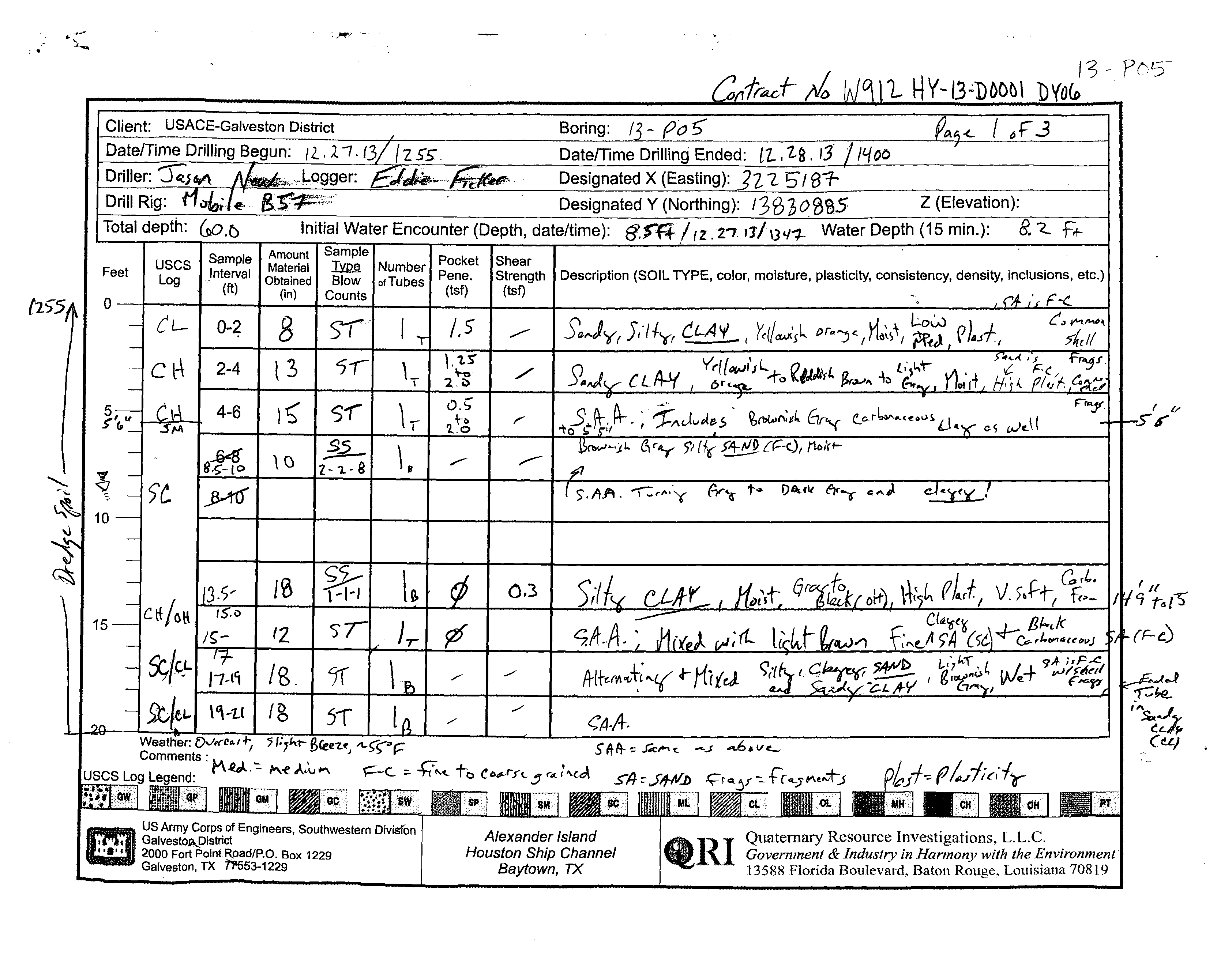
BORING ID:
13-P05
BORING TYPE:
Perimeter Levee
DEPTH:
60'
ELEVATION:
27.81'
X (US SURVEY FT):
3225186.78
Y (US SURVEY FT):
13830885.15
DEPTH TO WATER:
8.2'
:
..
.c
':)Of;? '-,
1'3 - PO?'
l1..,
2S.
13'
1-
':J
I 81-
Designated Y (Northing):
13620SSS
Z (Elevation):
Initial Water Encounter (Depth, date/time):
~ffl'
/
(Z
.rr
Jl/
\3"~
Water Depth (15 min.):
8."Z..
F.,..
uses
Sample
Material
~
Number Pene.
Strength
-I--"~'-I
1_IShe~
Description
(SOIL TYPE, color, moisture, plasticity, consistency, density, inclusions, etc.)
Feet
I
Log
...Interval
Obtained
Blow
of Tubes
(tsf)
(tsf)
:
(ft)
(in)
r.nllnt!':
(zS"5A
I 0
i
CL.
0-4
8
I S'f'l I
J
1.5
I ___
"
S'f),JYr 5,'fly, CLA'I'
_ I
'tc~a..Jt'sl t>r""j'lrt6~S+' ~:t,
P}uf
f
C~
2-4
l3
J'
1
'-I
.:.~
./
'l
L
Y~ll~IJ
:..r.,
~IPJ(L
Br""'1\
-k
-
4-6
I
l~
I
5"11
\,
~ ~)t
....,"""'-.
--
.
.# - ...
- - •
'8
I
10
15-=lCtf/Gl\
-"
,S,D
/~-
'2
~/Q- '-1'\~
I /8, I 1(' I \
'9.
I
m
US Army Corps of Engineers, Southwestern Divfs(on
I . , •
Galvestoa..!)lstrict
"'"
2000 Fort Point.R.oad/P.O, Box 1229
Galveston, TX
fHj53-1229
~{b!.r>O:,{
6r...r
e.C>-tl..o,.......
~ou~
eS
wc.U
F"''"'jI'.iLs
r
1/
/1t>,rr-
;"
0.3
J _
Bf..t.k
-.q--
C.,1.0I"4{~iNJ
./
1./
A-It~{~""~;
Y
4-
KUd
( .. ,+
9';'
I,F..c
vv~
vJ'i!.:;:
,
I
./
<'A-A--
Sll-~~
,J;c""c.
-J
-o.v~
Alexander Island
Houston
Ship Channel
Baytown, TX
flRI
Quaternary Resource Investigations,
L.L.c.
Government
&
Industry in Harmony with the Environment
13588 Florida Boulevard. Baton
Rouge, Louisiana 70819
27.8145'
, .
-,
.~.
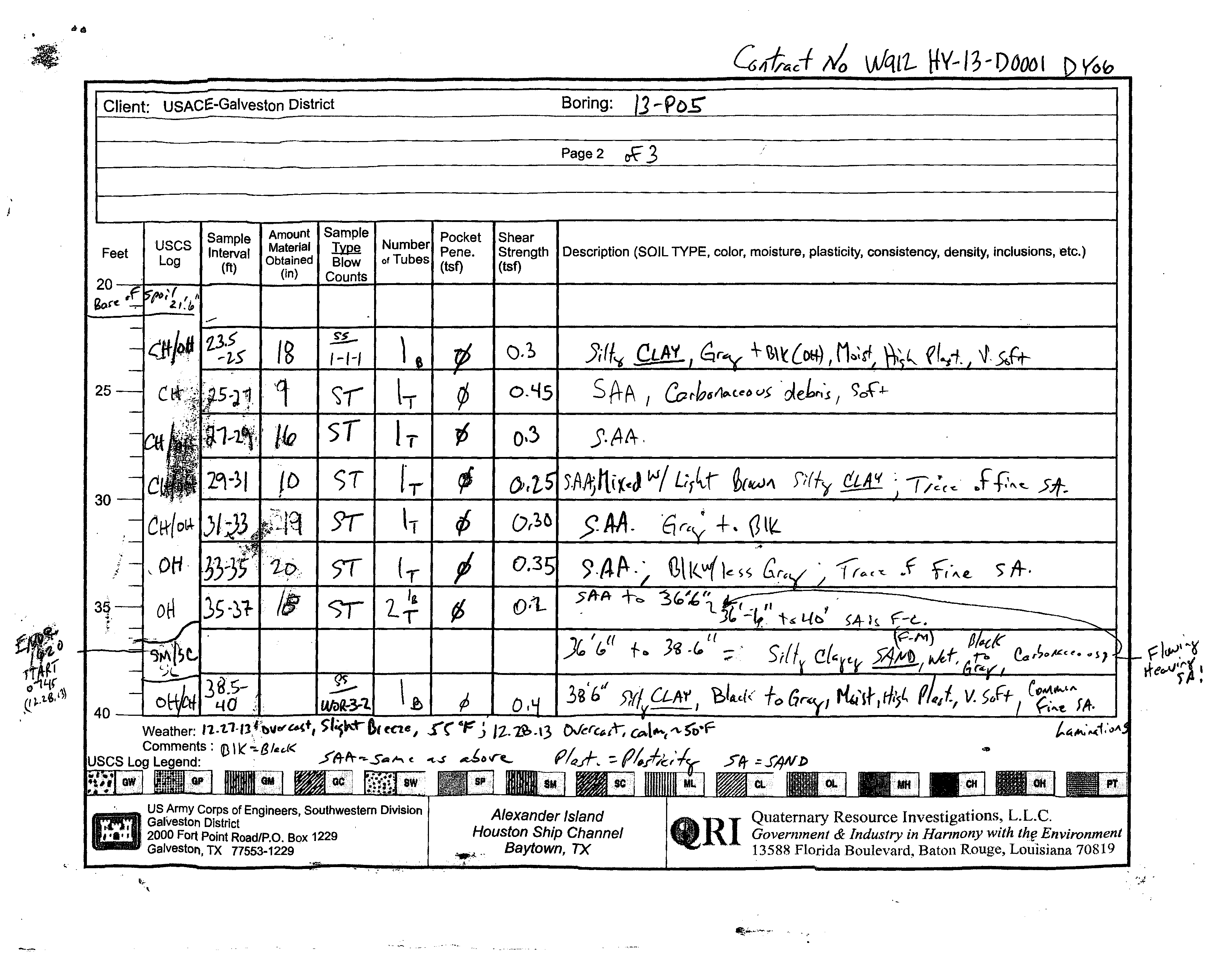
Client: USACE-Galveston District
Boring:
Page 2
~
3
Sample
Amount
Pocket
Shear
Feet
USCS
Interval
Material
Pene.
Strength
Log
(ft)
Obtained
(tsf)
(tst)
20
(in)
Description
(SOIL TYPE, color, moisture, plasticity, consistency, density, inclusions, etc.)
Sore
18
~
)
o.~
}i(
/-1-/
25
'q
~,-
IT
o.'-f5
SA-A
Co I'h6f1t,.C.
e
l>
v>
.
~ehf1~
/
C)o{'.1-
sT
IT
O'~
J.AA.
ST
f-r
).AAjIl{(otJ
~I
L;rlr
~{6(AJ~
: 1/:(,<-
..
t-0~~
30
9t
h
SM.
'6
~
• +. 0
llL
.!
,
,l'
0/.1
-
5T
.,--
f fro
Ir()<c"<-
w
,,,e.
5"
,4-.
S/
Jg'f/ 5)(/.
UAf I
40--~~~~~L-
_____
~~~
__
~L-~~~~L-
____
~==~~
____
~~~
__
~~
__
~
____
L-~~~
Weather:
11.t.l.'lf;b".....U(t,
Comments: Q) \k'
~
B
ItI!d<
toe
I
f(
c~
j
It.2?>.\3
lNerC6lr,
~l"""I"\,.SO·F-
f'~.A-.
=-
(l~.l;c;
m
",
US Army Corps of Engineers" Southwestern Division
1
,Galveston District
,
'."
'2000 Fort Point RoadfP.O. Box 1229
, Galveston, TX 77553-1229
Quaternary Resource Investigations,
L.L.c.
Government
&
Industry in Harmony with
th~
Environment
13588 Florida Boulevard, Baton Rouge, LOUisiana 70819
Alexander Island
Houston
Ship Channel
..........
Baytown, TX
,L-______________
~--~~
__
~~--------
______
~
______________________________---
19
/'106
./
. Client:
USACE-Galveston District
Total depth:
((,0.0
Sample
Amount
Sample
USCS
Material
~
Number
Feet
Log
Interval
Obtained
Blow
of Tubes
(ft)
(in)
Counts
40
16-~~
Il{
)T
)T
5M
~'l,L{~
15
fT
\
45
't~(S'
/1-
Sly
Ie
)'M.
G.-'-L{
50
55
SM
US Army Corps of Engineers, Southwestern Division
Galveston District
2000 Fort Point Road/P.O. Box 1229
Galveston, TX 77553-1229
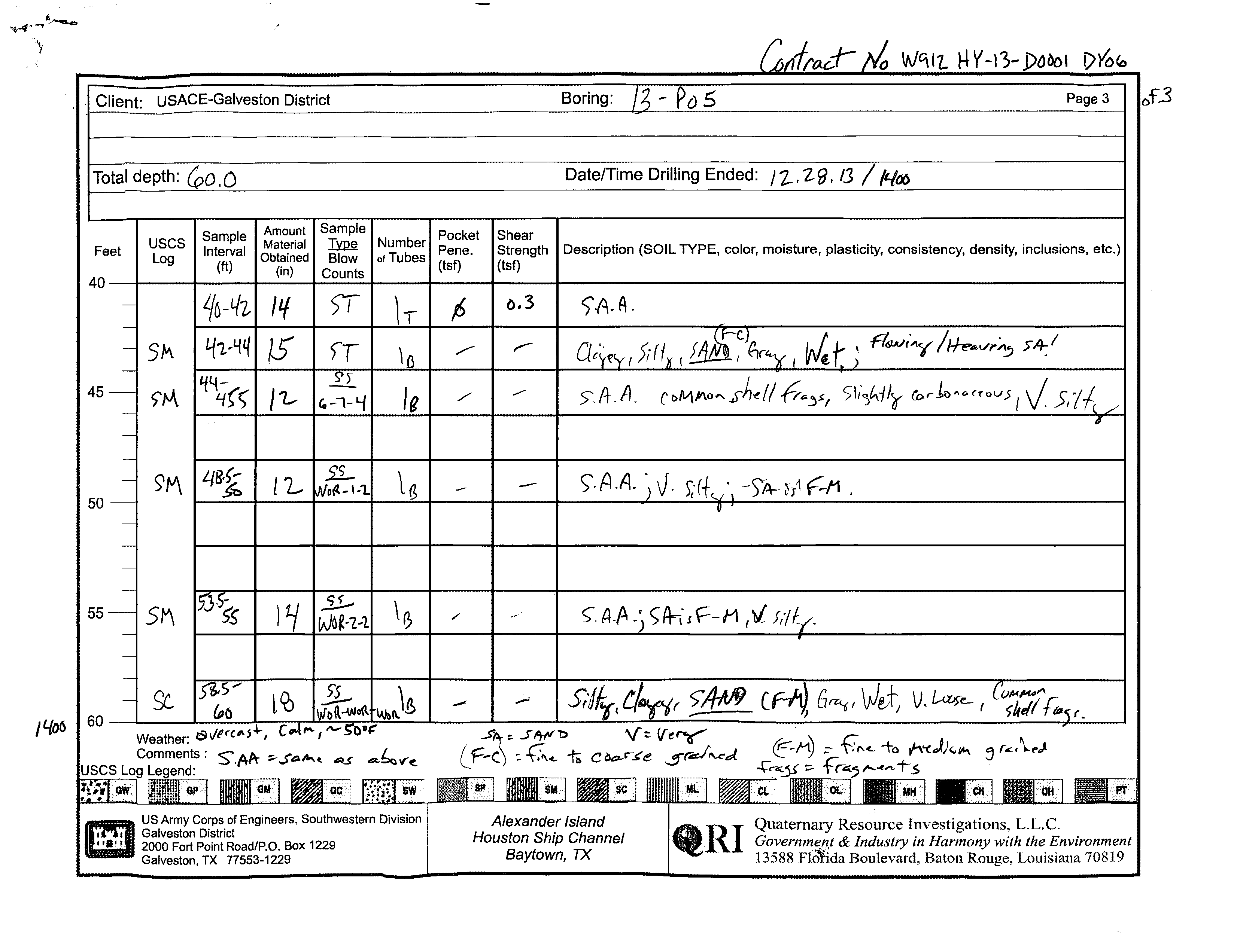
Boring:
- PaS
Page 3
DatelTime Drilling Ended:
17-,29,13 I NIX)
Pocket
Shear
Pene.
Strength
Description (SOIL TYPE, color, moisture, plasticity, consistency, density, inclusions, etc.)
(tsf)
(tsf)
f>
6.3
/"
~
Alexander Island
Houston
Ship Channel
Baytown,
TX
aRI Quaternary Resource Investigations,
L.L.c.
'II!..
Governme!Jl
&
Industry in Harmony with the Environment
13588
FI~da
Boulevard, Baton Rouge, Louisiana 70819
f3
14
14
23
29
28
28
29
31
66
74
75
85
70
52
86
43
45
89
103
103
113
13
19
17
19
80
39
29
25
63
40
73
68
68
64
111
112
74
77
58
60
0.3
0.3
0.45
0.3
0.25
0.30
0.35
1.5
1.25-2.0
0.5-2.0
0
0
0
0
0
0
0
0
8
13
15
0
10
0
18
12
18
18
0
18
9
16
10
19
20
ST
ST
ST
NR
SS
NR
SS
ST
ST
ST
NR
SS
ST
ST
ST
ST
ST
2-2-8
(10)
1-1-1
(2)
1-1-1
(2)
Sandy silty CLAY; yellowish orange, moist,
low to medium plasticity, with common shell
fragments, sand is fine to coarse grained
yellowish orange/reddish brown/light gray,
high plasticity
includes brownish gray carbonaceous CLAY
Silty SAND; fine to coarse grained, brownish
gray, moist
Silty clayey SAND; fine to coarse grained,
gray to dark gray, moist to wet
CLAY, gray to black; moist, high plasticity,
very soft, carbonaceous from 14.75 to 15'
mixed with clayey SAND, fine grained, light
brown and black carbonaceous SAND, fine
to coarse grained
alternating and mixed silty clayey SAND and
sandy CLAY, light brownish gray, wet, sand
is fine to coarse grained with shell
fragments
gray to black (OH), moist, high plasticity,
very soft
carbonaceous debris, soft
mixed with silty CLAY, light brown, with a
trace of fine sand
gray to black
black with a little gray
CL
SM
SC-
SM
CH
1.27
0.86
0.07
0.36
0.25
0.58
13
12
7
2
2
8
0
0
9
0
15
0
DRILLING CONTRACTOR
QRI
LOGGED BY
Eddie Ficker
GROUND ELEVATION
27.8145 ft
NORTHING
13830885 ft
WEATHER
cloudy, 55 to 50, slight breeze to calm
GROUND WATER LEVEL
HOLE SIZE
8.25 inches
EASTING
3225187 ft
DRILLING METHOD
Hollow Stem Auger
DRILLING RIG MAKE/MODEL
Mobile B57 on Gemco Articulated Platform
TOTAL DEPTH
60 ft
DATE STARTED
12/27/2013 12:55:00 PM
COMPLETED
12/28/2013 2:00:00 PM
AT TIME OF DRILLING
8.50 ft / Elev 19.31 ft
24 HOURS AFTER DRILLING
8.20 ft / Elev 19.61 ft
(Continued Next Page)
PLASTIC
LIMIT
PLASTICITY
INDEX
MINUS #200 SIEVE
CONTENT (%)
LIQUID
LIMIT
ATTERBERG
LIMITS
MOISTURE
CONTENT (%)
DRY UNIT WT.
(pcf)
FIELD TORVANE
(tsf)
POCKET PEN.
(tsf)
RECOVERY
(in)
SAMPLE TYPE
DEPTH
(ft)
0
5
10
15
20
25
30
35
SPT BLOW
COUNTS
(N VALUE)
GRAPHIC
LOG
MATERIAL DESCRIPTION
USCS SYMBOL
COMPRESSIVE
STRENGTH (tsf)
FAILURE
STRAIN (%)
CONFINING
PRESSURE (psi)
PAGE 1 OF 2
BORING NUMBER 13-P05
CLIENT
USACE-Galveston District
PROJECT NUMBER
W912HY-13-D-0001-DY06
PROJECT NAME
Alexander Island
PROJECT LOCATION
Alexander Island, Baytown, TX
COPY OF PEGGY LAKE GEOTECH BH - PEGGY LAKE TEMPLATE.GDT - 4/4/14 15:04 - F:\QRI DATA\TECHNICAL\JOBS (CURRENT)\ACE - GALVESTON\2012-12-20 GEOTECHNICAL CONTRACT\TASK ORDER DY06 2013-09-10 ALEXANDER ISLAND\DELIVERABLES\ALEXANDE
Quaternary Resource Investigations, LLC
13588 Florida Boulevard
Baton Rouge, LA 70820
Telephone: 225-292-1400
Fax: 225-292-1404
21
28
24
55 96
29
43
45
83
37
64
65
27
19
21
23
24
85
61
0.2
0.4
0.3
0
0
0
18
0
19
14
15
12
0
12
0
14
0
18
ST
NR
SS
ST
ST
SS
NR
SS
NR
SS
NR
SS
0-3-2
(5)
6-7-4
(11)
0-1-2
(3)
0-2-2
(4)
0-0-0
(0)
Silty CLAY; black with a little gray, moist,
high plasticity, very soft
Clayey SAND with SILT; fine to medium
grained, black to gray, wet, carbonaceous,
flowing heaving sand
CLAY; black to gray, moist, high plasticity,
very soft, with common fine sand
laminations
Clayey silty SAND; fine to coarse grained,
gray, wet, flowing heaving sand
with common shell fragments, very silty,
slightly carbonaceous
fine to medium grained
Silty clayey SAND; fine to medium grained,
gray, wet, very loose, with common shell
fragments
Bottom of borehole at 60.0 feet.
CL
SC-
SM
CH
SM
SC
0.35 2 19
PLASTIC
LIMIT
PLASTICITY
INDEX
MINUS #200 SIEVE
CONTENT (%)
LIQUID
LIMIT
ATTERBERG
LIMITS
MOISTURE
CONTENT (%)
DRY UNIT WT.
(pcf)
FIELD TORVANE
(tsf)
POCKET PEN.
(tsf)
RECOVERY
(in)
SAMPLE TYPE
DEPTH
(ft)
35
40
45
50
55
60
SPT BLOW
COUNTS
(N VALUE)
GRAPHIC
LOG
MATERIAL DESCRIPTION
USCS SYMBOL
COMPRESSIVE
STRENGTH (tsf)
FAILURE
STRAIN (%)
CONFINING
PRESSURE (psi)
PAGE 2 OF 2
BORING NUMBER 13-P05
CLIENT
USACE-Galveston District
PROJECT NUMBER
W912HY-13-D-0001-DY06
PROJECT NAME
Alexander Island
PROJECT LOCATION
Alexander Island, Baytown, TX
COPY OF PEGGY LAKE GEOTECH BH - PEGGY LAKE TEMPLATE.GDT - 4/4/14 15:04 - F:\QRI DATA\TECHNICAL\JOBS (CURRENT)\ACE - GALVESTON\2012-12-20 GEOTECHNICAL CONTRACT\TASK ORDER DY06 2013-09-10 ALEXANDER ISLAND\DELIVERABLES\ALEXANDE
Quaternary Resource Investigations, LLC
13588 Florida Boulevard
Baton Rouge, LA 70820
Telephone: 225-292-1400
Fax: 225-292-1404
3/8 4 10 40 100 200 gravel sand silt clay
sieve
200
C Wc γd
C Wcγd
C φ Wc
C φ c̕φ̕Wcγd
ft
tsf tsf bl/ft % % % % % % % % % % % % % %
% pcf
ksf
% pcf
ksf
% pcf
ksf
º
%
ksf
º
ksf
º
%
pcf
USCS
Symbol
SUMMARY TABLE OF LABORATORY TEST DATA
Unconfined Compression
UU Triaxial Test
CU Triaxial Test
Symbol
Symbol
Symbol
γd
Direct Shear
Symbol
Strenght Tests
Wc
Atterberg Limits
PP
% by weight passing sieve
Client: QRI
Terracon Project # : 92135456
Grain Size Analysis
SPTn
Project Name: Alexander Island
Boring
Depth
LL
PL
PI
Field Tests
TV
0-2
1.5
21
2-3.5
3.5-5
3
27
11
16
99
98
98
83
38
2
60
38
SC
19
5-8.5
8.5-10
0-0.5
0.4
2
100
100
98
97
0
3
26
70
97
CH*
39
Complete Sieve test not assigned but it was performed with hydrometer.
10-12
0.5-1.0
74
55
0.44
74
55
CH**
12-14
100
100
90
8
0
92
8
SP-SM*
20
14-16
0
0.2
12
35
16-18
17-19
0
0.25
90
19-21
0-0.25
0.3
112
35
77
100
100
98
0
2
15
83
98
CH*
38
73
0.45
38
73
CH**
21-23
0-0.25
0.5
113
30
83
CH*
84
53
0.68
84
53
CH**
23-25
0
0.4
149
37
112
CH*
79
54
0.69
79
54
CH**
25-28
26-28
28-28.5
28.5-30
0-0.25
0.25
3
70
30-32
0
0.35
118
30
88
CH*
71
58
0.65
71
58
CH**
32-34
0.25
0.5
67
34-36
0
0.35
118
32
86
100
99
0
1
11