Aptim Environmental & Infrastructure, LLC
6401 Congress Avenue, Suite 140
Boca Raton, Florida 33487
Phone # 1-561-391-8102
Legend for Geotechnical Data
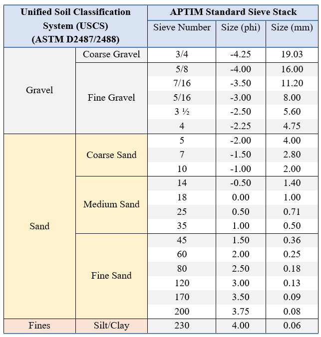
Grain Size Scale for Sediments
Proportional Definition of Descriptive Terms
Descriptive Term
Range of Proportions
Sandy, gravelly, etc.
35 % to 50 %
Some
20 % to 35 %
Little
10 % to 20 %
Trace
1 % to 10 %
Consistency of Cohesive Soils
Description
Consistency
Index
Approximate
Undrained Shear
Strength (kPa)
Field Identification
Hard
Over 300
Indented with difficulty by thumbnail, brittle.
Very Stiff
>1
150-300
Readily indented by thumbnail, still very tough.
Stiff
0.75-1
75-150
Readily indented by thumb but penetrated only with difficulty. Cannot
be moulded in the fingers.
Firm
0.5-0.75
40-75
Can be penetrated several centimeters by thumb with moderate effort
and moulded in fingers by strong pressure.
Soft
< 0.5
20-40
Easily penetrated several centimeters by thumb, easily moulded.
Very Soft
Less than 20
Easily penetrated several centimeters by fist, exudes between fingers
when squeezed in fist.
Source: Engineering Properties of Soils and Rocks, Fourth Edition by Fred G. Bell
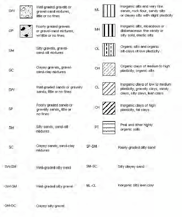
USCS Classifications
Refers to the Army Corps of Engineers Unified Soils Classification System. Class types
are defined primarily by grain size, sorting and percent of material passing the #200 sieve.
Classification of materials on the core logs based on visual field examinations are identified on
the core logs under the Classification of Materials Description. Classifications based on
laboratory sieve analyses are identified on the core logs in the Legend and under Remarks.
Note: Information is after ACOE Atlantic Division Manual # 1110-1-1 titled
Engineering and Design
Geotechnical Manual for Surface and Subsurface Investigations
LEAN CLAY, very soft, little silt, trace shell hash, silt
and shell hash typically distributed in laminae, silt
increases with depth in layer, 1.5" silt pocket with shell
hash @ 1.1', very dark gray (2.5Y-3/1), (CL).
LEAN CLAY, soft, little silt, trace rock fragments, trace
sand, fine grained, quartz, trace shell hash, sand and
shell hash distributed in silt pockets up to 1.0", rock
fragments are fragments of partially lithified clay up to
0.19", 0.5" pocket of rock fragments @ 4.4', very dark
greenish gray (10Y-3/1), (CL).
Sandy FAT CLAY, firm, trace organics, trace shell
hash, trace silt, trace whole shell, oxidation throughout
layer, sand component is fine grained quartz
distributed in pockets up to 1.0", 2.5" shell hash
pocket @ 4.9', (0.5" x 0.75") whole bivalve @ 5.0',
possible bioturbation between 6.0' & 6.5' and between
7.7' & 8.0', 0.25" organic pocket @ 7.7', 1.5" clay
pocket @ 8.5', 1.0" clay pocket @ 8.7', color is
mottled yellowish brown (10YR-5/6) and gray
(5Y-6/1), (CH).
FAT CLAY, hard, trace sand, fine grained, quartz,
trace silt, trace wood fragments, sand increases with
depth in layer, 0.75" partially lithified clay pocket @
9.4', oxidation between 9.0' & 9.4' and between 10.5'
& 11.1', 0.5" organic pocket @ 10.0', 2.5" organic
pocket @ 11.4', possible bioturbation between 11.8' &
12.2', color is mottled dark yellowish brown
(10YR-4/4) and dark gray (2.5Y-4/1), (CH).
FAT CLAY, hard, trace sand, fine grained, quartz,
trace silt, trace wood fragments, hardnesses
decreases with depth in layer, sand increases with
depth in layer, wood fragments are possible tree
roots, possible bioturbation between 13.0' & 13.6',
14.4' & 16.1' and between 17.7' & 17.9', 1.5" sand
pockets @ 14.9' and 16.1', 2 (0.25" x 7.0") wood
fragments @ 14.9', wood fragments up to 4.25"
between 16.4' & 17.6', Bit sample from 17.9' to 18.2',
dark gray (2.5Y-4/1), (CH).
No recovery.
End of Boring
-35.6
-39.2
-43.3
-46.7
-52.5
-53.3
1.3
4.9
9.0
12.4
18.2
19.0
T1
T2
T3
Sample #T1, Depth = 10.3'
Ave. Field Vane (tsf): 0.46
Sample #T2, Depth = 13.4'
Ave. Field Vane (tsf): 0.56
Sample #T3, Depth = 16.3'
Ave. Field Vane (tsf): 0.26
3. DRILLING AGENCY
2. BORING DESIGNATION
0
0.0 Ft.
LOCATION COORDINATES (ft)
TX GLO Region 1 Recon Geotechnical Sand Search
Jefferson, Chambers, Galveston and Brazoria Co.
15. DATE BORING
0.0
18.2 Ft.
SM
10. COORDINATE SYSTEM/DATUM
11. MANUFACTURER'S DESIGNATION OF DRILL
DISTURBED
UNDISTURBED (UD)
18. SIGNATURE AND TITLE OF INSPECTOR
14. ELEVATION GROUND WATER
Texas State Plane South
COMPLETED
19.0 Ft.
STARTED
3.0 In.
X = 3,554,383 Y = 13,784,030
-34.3
VERTICAL
VERTICAL
INCLINED
0.0 Ft.
8. TOTAL DEPTH OF BORING
TXGLO1-VC-23-003
AUTO HAMMER
MANUAL HAMMER
APTIM
6. THICKNESS OF OVERBURDEN
CONTRACTOR FILE NO.
7. DEPTH DRILLED INTO ROCK
10-06-23
-34.3 Ft.
DIVISION
INSTALLATION
16. ELEVATION TOP OF BORING
17. TOTAL RECOVERY FOR BORING
NAVD88
3
APTIM SEAS VC-700 Vibracore
9. SIZE AND TYPE OF BIT
12. TOTAL SAMPLES
13. TOTAL NUMBER CORE BOXES
DEG. FROM
VERTICAL
5. DIRECTION OF BORING
BEARING
4. NAME OF DRILLER
HORIZONTAL
APTIM
DRILLING LOG
NAD 1983
1. PROJECT
10-06-23
%
REC.
Boring Designation
REMARKS
The USCS classification system defines silt as the
percent passing the No.200 (0.075 mm) sieve
SHEET 1
BOX OR
SAMPLE
CLASSIFICATION OF MATERIALS
Depths and elevations based on measured values
ELEV.
(ft)
LEGEND
DEPTH
(ft)
0
5
10
15
20
25
TXGLO1-VC-23-003
JUN 04
SAJ FORM 1836
OF 1 SHEETS
REGION1_RECON_GEOTECH.GPJ 3/25/24
CORE ID
SAMPLE DEPTH
(ft)
TORVANE
(kg/cm²)
TORVANE
(tsf)
TORVANE
(kpa)
DESCRIPTION
1
TXGLO1-VC-23-001
3.0
1.5
0.15
147.10
Stiff
6.0
1.0
0.10
98.07
Stiff
10.3
4.5
0.46
441.30
Hard
13.4
5.5
0.56
539.37
Hard
16.3
2.5
0.26
245.17
Very Stiff
9.1
3.0
0.31
294.20
Very Stiff
11.9
5.0
0.51
490.33
Hard
14.1
6.0
0.61
588.40
Hard
4.8
6.0
0.61
588.40
Hard
7.5
5.0
0.51
490.33
Hard
13.5
5.5
0.56
539.37
Hard
16.5
3.5
0.36
343.23
Hard
TXGLO1-VC-23-006
9.0
5.5
0.56
539.37
Hard
15.1
1.5
0.15
147.10
Stiff
7.1
5.5
0.56
539.37
Hard
8.1
9.0
0.92
882.60
Hard
10.2
8.0
0.82
784.53
Hard
16.0
8.0
0.82
784.53
Hard
TXGLO1-VC-23-009
8.0
7.0